IMAGES TAKEN NEAR TO
Monkham Hill, WR10 3FE
Introduction
This page details the photographs taken nearby to Monkham Hill, WR10 3FE by members of the Geograph project.
The Geograph project started in 2005 with the aim of publishing, organising and preserving representative images for every square kilometre of Great Britain, Ireland and the Isle of Man.

There are currently over 7.5m images from over14,400 individuals and you can help contribute to the project by visiting https://www.geograph.org.uk
Image Map (Loading...)


Getting Data...Please wait
Leaflet Map data © OpenStreetMap
Images are licensed for reuse under creativecommons.org/licenses/by-sa/2.0
Notes
- Clicking on the map will re-center to the selected point.
- The higher the marker number, the further away the image location is from the centre of the postcode.
Image Listing (78 Images Found)
Images are licensed for reuse under creativecommons.org/licenses/by-sa/2.0
Image
Details
Distance
1
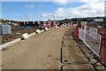
Entrance to a building site
Building work has begun on this site to the north of Eckington, which I previously photographed in April of this year Image
Image: © Philip Halling
Taken: 3 Oct 2021
0.03 miles
2

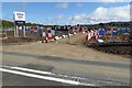
Building site at Eckington
Building work has begun on this site to the north of Eckington, which I previously photographed in April of this year Image
Image: © Philip Halling
Taken: 3 Oct 2021
0.03 miles
3
Building land at Eckington
Another field disappearing and will soon be another building site, this field is just north of the village of Eckington.
Image: © Philip Halling
Taken: 26 Apr 2021
0.03 miles
4
Housing building at Eckington
Building work has begun on this site to the north of Eckington, which I previously photographed in April of this year Image
Image: © Philip Halling
Taken: 3 Oct 2021
0.03 miles
5
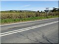
The B4080 approaching Eckington
The field on the left has planning permission and awaits the builders.
Image: © Philip Halling
Taken: 26 Apr 2021
0.07 miles
6

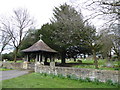
Eckington cemetery
On the east side of the B4084.
Image: © Trevor Rickard
Taken: 1 Dec 2008
0.10 miles
7
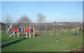
Eckington play area
Near the Pershore Road in the corner of the recreation ground is a well-appointed play area, opened in 2007. Defford village in the distance on the right.
Image: © Trevor Rickard
Taken: 1 Dec 2008
0.11 miles
9
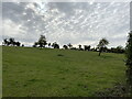
Field near Eckington
Rising away from the flood plain of the River Avon. Eckington Caravan Park hopes to expand onto this field.
Image: © Bill Boaden
Taken: 9 Oct 2020
0.13 miles
10
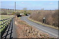
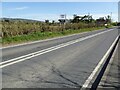
Path beside the B4080
Path beside the B4080 to the south of Eckington Bridge.
Image: © Philip Halling
Taken: 26 Feb 2012
0.13 miles