IMAGES TAKEN NEAR TO
Pershore Road, PERSHORE, WR10 3DX
Introduction
This page details the photographs taken nearby to Pershore Road, WR10 3DX by members of the Geograph project.
The Geograph project started in 2005 with the aim of publishing, organising and preserving representative images for every square kilometre of Great Britain, Ireland and the Isle of Man.

There are currently over 7.5m images from over14,400 individuals and you can help contribute to the project by visiting https://www.geograph.org.uk
Image Map (Loading...)


Getting Data...Please wait
Leaflet Map data © OpenStreetMap
Images are licensed for reuse under creativecommons.org/licenses/by-sa/2.0
Notes
- Clicking on the map will re-center to the selected point.
- The higher the marker number, the further away the image location is from the centre of the postcode.
Image Listing (23 Images Found)
Images are licensed for reuse under creativecommons.org/licenses/by-sa/2.0
Image
Details
Distance
1
Two outbuildings at Great Comberton
From the other side of the road shown in Image The central building is at Krnts far, and is across another road.
Image: © Derek Harper
Taken: 1 Jul 2017
0.02 miles
2
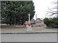
Great Comberton War Memorial: early March 2016
Image: © Basher Eyre
Taken: 6 Mar 2016
0.06 miles

4

Entering Great Comberton
On foot, that is. Here footpath GC 504 reaches gates leading onto the lane from Little Comberton at a bend. The signpost you can just glimpse between the trees on the right is at the junction with the lane to Pershore.
Image: © Derek Harper
Taken: 1 Jul 2017
0.06 miles
5

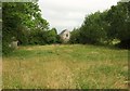
Grass field, Great Comberton
Looking right from where Image was taken, with trees lining the road to Little Comberton.
Image: © Derek Harper
Taken: 1 Jul 2017
0.07 miles
6

Footpath to Great Comberton
Footpath GC 504 crosses this last field to reach the lane from Little Comberton near Lower End Farm (left), as shown in Image
Image: © Derek Harper
Taken: 1 Jul 2017
0.07 miles
7
More land for building
The hedge has been removed and Heras fencing has been erected beside this road in Great Comberton, probably in preparation for building.
Image: © Philip Halling
Taken: 21 May 2022
0.07 miles
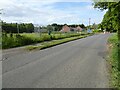
9

Road past war memorial, Great Comberton
Placing http://www.geograph.org.uk/search.php?i=73314256 in context, with a tree-lined road entering the village from Little Comberton.
Image: © Derek Harper
Taken: 1 Jul 2017
0.10 miles
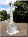
10

War memorial, Great Comberton
Another view of the memorial on its grass and poppy triangle shown in http://www.geograph.org.uk/search.php?i=73315651 . The track leads to the C17 Shelton farmhouse.
Image: © Derek Harper
Taken: 1 Jul 2017
0.10 miles