IMAGES TAKEN NEAR TO
Hollands Road, PERSHORE, WR10 3DF
Introduction
This page details the photographs taken nearby to Hollands Road, WR10 3DF by members of the Geograph project.
The Geograph project started in 2005 with the aim of publishing, organising and preserving representative images for every square kilometre of Great Britain, Ireland and the Isle of Man.

There are currently over 7.5m images from over14,400 individuals and you can help contribute to the project by visiting https://www.geograph.org.uk
Image Map
Images are licensed for reuse under creativecommons.org/licenses/by-sa/2.0
Notes
- Clicking on the map will re-center to the selected point.
- The higher the marker number, the further away the image location is from the centre of the postcode.
Image Listing (18 Images Found)
Images are licensed for reuse under creativecommons.org/licenses/by-sa/2.0
Image
Details
Distance
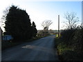
2
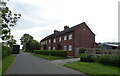
New houses at Eckington Farm
These two new houses, built in 2013 according to the tablet in the gable, on the site of farm cottages which I photographed fifteen years ago in 2005 which became the first picture uploaded in this grid square Image
Image: © Philip Halling
Taken: 13 Nov 2020
0.01 miles
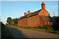
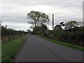
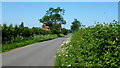
3
Road passing Eckington Field Farm
A country road to Great Comberton passing Eckington Field Farm.
Image: © Philip Halling
Taken: 28 Dec 2016
0.05 miles
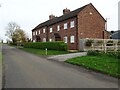
4
Farm Cottages
The backs of farm cottages at Eckington Fields Farm.
Image: © Philip Halling
Taken: 12 Sep 2005
0.06 miles
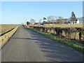
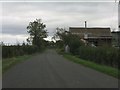
5
The lane past Eckington Field Farm
This road connects the Combertons with Eckington. Here we are looking gently downhill towards the River Avon.
Image: © David Purchase
Taken: 29 Dec 2013
0.07 miles
7
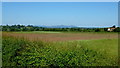
Flat land south of Eckington
Strensham Hill to the left, Malvern Hills in the far distance.
Image: © Jonathan Billinger
Taken: 25 Jun 2013
0.14 miles
8
House reconstruction on the lane to The Combertons
Image: © Peter Whatley
Taken: 12 Oct 2011
0.17 miles
9
Comberton Road
Looking west towards the Tewkesbury Road.
Image: © Jonathan Billinger
Taken: 25 Jun 2013
0.19 miles
10
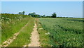
Farm track and footpath
Heading north past a wheat crop from Comberton Road towards Eckington.
Image: © Jonathan Billinger
Taken: 25 Jun 2013
0.22 miles