IMAGES TAKEN NEAR TO
Eckington Road, PERSHORE, WR10 3DA
Introduction
This page details the photographs taken nearby to Eckington Road, WR10 3DA by members of the Geograph project.
The Geograph project started in 2005 with the aim of publishing, organising and preserving representative images for every square kilometre of Great Britain, Ireland and the Isle of Man.

There are currently over 7.5m images from over14,400 individuals and you can help contribute to the project by visiting https://www.geograph.org.uk
Image Map (Loading...)


Getting Data...Please wait
Leaflet Map data © OpenStreetMap
Images are licensed for reuse under creativecommons.org/licenses/by-sa/2.0
Notes
- Clicking on the map will re-center to the selected point.
- The higher the marker number, the further away the image location is from the centre of the postcode.
Image Listing (21 Images Found)
Images are licensed for reuse under creativecommons.org/licenses/by-sa/2.0
Image
Details
Distance
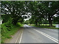
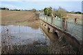
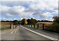
3
Defford Bridge and Baker's Hill
Defford Bridge carries the A4104 over Bow Brook, a tributary of the River Avon, to the north of the village of Defford. A recent collision has breached a hole in the railings on the left. Baker's Hill is the incline the road climbs on the opposite side of the bridge.
Image: © Philip Halling
Taken: 23 Nov 2008
0.15 miles
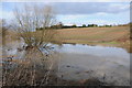
4
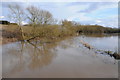
A flooded Bow Brook
A downstream view of a flooded Bow Brook viewed from Defford Bridge.
Image: © Philip Halling
Taken: 17 Mar 2013
0.15 miles
5
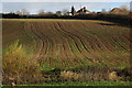
Arable field on Baker's Hill
Arable field on Baker's Hill viewed across Bow Brook near Bridge Farm.
Image: © Philip Halling
Taken: 23 Nov 2008
0.15 miles
6
Defford Bridge
Defford Bridge crossing a flooded Bow Brook with the A4104 ascending Bakers Hill in the background.
Image: © Philip Halling
Taken: 17 Mar 2013
0.16 miles
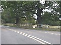
7
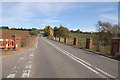
Defford Bridge, Worcestershire
The Upton upon Severn to Pershore road (the A4104) crosses a small tributary to the River Avon at Defford Bridge.
Image: © Roger Davies
Taken: 10 Oct 2008
0.16 miles
8
Flood Bow Brook and Bakers Hill
View across a flooded Bow Brook near Deffford Bridge with arable land on Bakers Hill in the background.
Image: © Philip Halling
Taken: 17 Mar 2013
0.16 miles

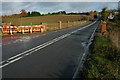
10
Defford Bridge
The bridge crosses Bow Brook.
Image: © nick macneill
Taken: 12 Oct 2012
0.17 miles