IMAGES TAKEN NEAR TO
Defford Road, PERSHORE, WR10 3BX
Introduction
This page details the photographs taken nearby to Defford Road, WR10 3BX by members of the Geograph project.
The Geograph project started in 2005 with the aim of publishing, organising and preserving representative images for every square kilometre of Great Britain, Ireland and the Isle of Man.

There are currently over 7.5m images from over14,400 individuals and you can help contribute to the project by visiting https://www.geograph.org.uk
Image Map
Images are licensed for reuse under creativecommons.org/licenses/by-sa/2.0
Notes
- Clicking on the map will re-center to the selected point.
- The higher the marker number, the further away the image location is from the centre of the postcode.
Image Listing (41 Images Found)
Images are licensed for reuse under creativecommons.org/licenses/by-sa/2.0
Image
Details
Distance
1
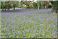
Bluebells beside the A4104
Every springtime there is a magnificent display of bluebells in this extended garden beside the A4104 to the west of Pershore.
Image: © Philip Halling
Taken: 24 Apr 2011
0.02 miles
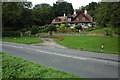
2
Houses on the A4104 on the edge of Pershore
Image: © Jeff Gogarty
Taken: 18 Aug 2022
0.05 miles
3
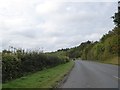
Defford Road approaching Tiddesley Wood, near Pershore
Some maps spell the wood Tyddesley; the road is following the river Avon on the left
Image: © David Smith
Taken: 8 Oct 2016
0.05 miles
4
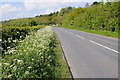
The A4104 near Pershore
Cow parsley on the side of the A4104 to the south of Pershore as it approaches Tiddesley Wood.
Image: © Philip Halling
Taken: 19 May 2013
0.05 miles
5
House overlooking the River Avon
House beside the A4104 on the edge of Tyddesley Wood and overlooking the River Avon.
Image: © Philip Halling
Taken: 14 Sep 2008
0.06 miles
6
House overlooking the River Avon
House on the A4104, overlooking the River Avon viewed through cow parsley and dandelions on the bank of the river.
Image: © Philip Halling
Taken: 19 May 2013
0.06 miles
7
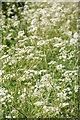
Cow parsley
Cow parsley or Anthriscus sylvestris is a common sight growing on the road verges each May.
Image: © Philip Halling
Taken: 19 May 2013
0.07 miles
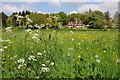
8
Water meadow and house near the A4104
Looking north to the house, which is on the other side of the main road. The public footpath on the right leads up to the road.
Image: © Trevor Rickard
Taken: 1 Dec 2008
0.07 miles
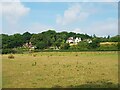
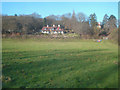
9
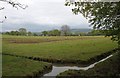
Orchard Farm
Viewed from the edge of Tiddesley Wood.
Bredon Hill in the distance.
Image: © Bob Embleton
Taken: 2 May 2010
0.09 miles
10
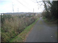
Short lane to the A4104
Looking south-east to the main road at the end of the lane below.
Image: © Trevor Rickard
Taken: 1 Dec 2008
0.09 miles