IMAGES TAKEN NEAR TO
Roman Meadow, PERSHORE, WR10 3AJ
Introduction
This page details the photographs taken nearby to Roman Meadow, WR10 3AJ by members of the Geograph project.
The Geograph project started in 2005 with the aim of publishing, organising and preserving representative images for every square kilometre of Great Britain, Ireland and the Isle of Man.

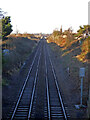
There are currently over 7.5m images from over14,400 individuals and you can help contribute to the project by visiting https://www.geograph.org.uk
Image Map (Loading...)


Getting Data...Please wait
Leaflet Map data © OpenStreetMap
Images are licensed for reuse under creativecommons.org/licenses/by-sa/2.0
Notes
- Clicking on the map will re-center to the selected point.
- The higher the marker number, the further away the image location is from the centre of the postcode.
Image Listing (115 Images Found)
Images are licensed for reuse under creativecommons.org/licenses/by-sa/2.0
Image
Details
Distance
2
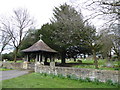
Eckington play area
Near the Pershore Road in the corner of the recreation ground is a well-appointed play area, opened in 2007. Defford village in the distance on the right.
Image: © Trevor Rickard
Taken: 1 Dec 2008
0.03 miles
3

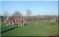
Eckington cemetery
On the east side of the B4084.
Image: © Trevor Rickard
Taken: 1 Dec 2008
0.06 miles
4
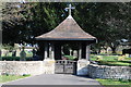
Lych gate, Eckington Cemetery
Lych gate entrance Eckington Cemetery off the B4080.
Image: © Philip Halling
Taken: 26 Feb 2012
0.07 miles
5
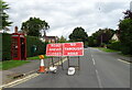
B4080 heading north from Eckington
But not today unless on foot or bicycle.
Image: © JThomas
Taken: 13 Aug 2021
0.07 miles
7
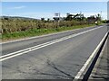
The B4080 approaching Eckington
The field on the left has planning permission and awaits the builders.
Image: © Philip Halling
Taken: 26 Apr 2021
0.09 miles
8
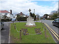
Eckington War Memorial: early March 2016
Image: © Basher Eyre
Taken: 6 Mar 2016
0.10 miles
9
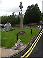
Village Cross, Eckington
A medieval base and shaft, a local historian commented that it was moved to its current position in 1897 when the Maltese cross-head was added. At the junction of Drakes Bridge Road and Church Street (B4080). On the South face the inscription translates to "God Save the Queen 1897". Notably the point and M of Reginam are overlaid. On the North face the weathered lettering may have read "God Save [the Queen etc]"
Grade II listed Nᴼ 1319823 https://historicengland.org.uk/listing/the-list/list-entry/1319823
Inscription: DOMINE•SALVAM•FAC•REGINAM•MDCCCXCVII
Milestone Society National ID: WOWA_ECK
Image: © Mr Red
Taken: 22 Aug 2023
0.10 miles
10
Eckington War Memorial and Village Cross
Image: © David Smith
Taken: 8 Oct 2016
0.10 miles