IMAGES TAKEN NEAR TO
Upper End, PERSHORE, WR10 3AA
Introduction
This page details the photographs taken nearby to Upper End, WR10 3AA by members of the Geograph project.
The Geograph project started in 2005 with the aim of publishing, organising and preserving representative images for every square kilometre of Great Britain, Ireland and the Isle of Man.

There are currently over 7.5m images from over14,400 individuals and you can help contribute to the project by visiting https://www.geograph.org.uk
Image Map (Loading...)


Getting Data...Please wait
Leaflet Map data © OpenStreetMap
Images are licensed for reuse under creativecommons.org/licenses/by-sa/2.0
Notes
- Clicking on the map will re-center to the selected point.
- The higher the marker number, the further away the image location is from the centre of the postcode.
Image Listing (12 Images Found)
Images are licensed for reuse under creativecommons.org/licenses/by-sa/2.0
Image
Details
Distance
3
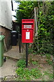
Elizabeth II postbox, Upper End, Birlingham
Postbox No. WR810 303.
Image: © JThomas
Taken: 13 Aug 2021
0.07 miles

6
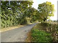
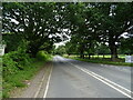
Road into Birlingham
Country road into Birlingham from the B4080.
Image: © Philip Halling
Taken: 5 Nov 2016
0.23 miles
9
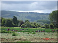
Fields in Birlingham
People working in the fields in Birlingham under Bredon Hill
Image: © Alpacaandrea
Taken: 7 Jul 2007
0.24 miles