IMAGES TAKEN NEAR TO
Paynes Lane, PERSHORE, WR10 2QJ
Introduction
This page details the photographs taken nearby to Paynes Lane, WR10 2QJ by members of the Geograph project.
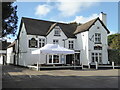
The Geograph project started in 2005 with the aim of publishing, organising and preserving representative images for every square kilometre of Great Britain, Ireland and the Isle of Man.

There are currently over 7.5m images from over14,400 individuals and you can help contribute to the project by visiting https://www.geograph.org.uk
Image Map (Loading...)


Getting Data...Please wait
Leaflet Map data © OpenStreetMap
Images are licensed for reuse under creativecommons.org/licenses/by-sa/2.0
Notes
- Clicking on the map will re-center to the selected point.
- The higher the marker number, the further away the image location is from the centre of the postcode.
Image Listing (111 Images Found)
Images are licensed for reuse under creativecommons.org/licenses/by-sa/2.0
Image
Details
Distance
1
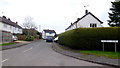
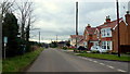
Sandys Close, Fladbury
There's no apostrophe on the road sign.
By coincidence I happened to be listening to Strawbs' 'Grave New World' in my car at the time - Sandy Denny was a member in the 1960's.
Image: © Jonathan Billinger
Taken: 2 Feb 2015
0.09 miles
2
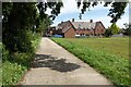
Footpath entering Fladbury
Shakespeare's Avon Way, a long distance path follows this farm road,
Image: © Philip Halling
Taken: 11 Aug 2023
0.10 miles
3
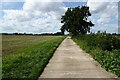
Shakespeare's Avon Way
This farm road is followed by Shakespeare's Avon Way, pictured here to the west of the village of Fladbury.
Image: © Philip Halling
Taken: 11 Aug 2023
0.12 miles
4
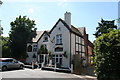
The 'Anchor', Fladbury, Worcestershire
Image: © Dr Neil Clifton
Taken: 21 Jul 2008
0.13 miles
5
Broadway Lane, Fladbury
The road leads on to a dead end on the Avon floodplain, not Broadway.
Image: © Jonathan Billinger
Taken: 2 Feb 2015
0.14 miles
6
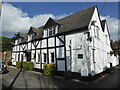
The Maltings, Fladbury
British Listed Buildings website refers to this as "Moorings". A 17th century timber framed house, Listed Grade II.
Image: © Chris Allen
Taken: 24 Feb 2022
0.14 miles
7
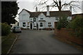
Chequers Inn, Fladbury
One of two public houses in the village of Fladbury.
Image: © Philip Halling
Taken: 30 Nov 2008
0.15 miles
9
Anchor Inn, Fladbury
A 17th century building with the timber framing largely hidden by stucco. Listed Grade II.
Image: © Chris Allen
Taken: 24 Feb 2022
0.16 miles
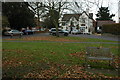
10
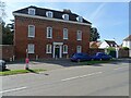
The Monastery
Opposite Fladbury church stands this mid-18th century Georgian brick built house with the curious name of 'The Monastery'. The house is Grade II listed, see: https://historicengland.org.uk/listing/the-list/list-entry/1039156. The name of the house may stem from there being monks here before Evesham Abbey was established, Fladbury had been a site of Christian worship since monks settled here in 691AD when Ethelred, King of Mercia, made a grant of land to Oft for the second Bishop of Worcester.
Image: © Philip Halling
Taken: 4 Apr 2021
0.16 miles