IMAGES TAKEN NEAR TO
Mill Bank, PERSHORE, WR10 2QA
Introduction
This page details the photographs taken nearby to Mill Bank, WR10 2QA by members of the Geograph project.
The Geograph project started in 2005 with the aim of publishing, organising and preserving representative images for every square kilometre of Great Britain, Ireland and the Isle of Man.

There are currently over 7.5m images from over14,400 individuals and you can help contribute to the project by visiting https://www.geograph.org.uk
Image Map
Images are licensed for reuse under creativecommons.org/licenses/by-sa/2.0
Notes
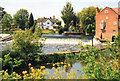
- Clicking on the map will re-center to the selected point.
- The higher the marker number, the further away the image location is from the centre of the postcode.
Image Listing (171 Images Found)
Images are licensed for reuse under creativecommons.org/licenses/by-sa/2.0
Image
Details
Distance
2
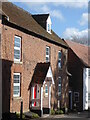
Avon Cottage, Fladbury
This is not a listed building.
Image: © Chris Allen
Taken: 24 Feb 2022
0.02 miles
3
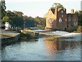
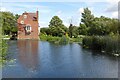
River Avon at Fladbury
Disused lock in the foreground. Weir in front of mill. The current lock is behind this mill building. Above the weir the rope ferry is carrying a passenger across.
Image: © Jennifer Luther Thomas
Taken: 4 Nov 2006
0.04 miles
4
Fladbury weir
View westwards across the river Avon. The boat channel is in the foreground and heads to the lock to the right of the mill-house. On the far side of the weir is the disused old lock.
Image: © Trevor Rickard
Taken: Unknown
0.04 miles
5
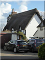
Croeso Cottage and Thatch Cottage, Fladbury
These are 17th century with timber framing and thatched roofs. Listed Grade II. Rather tucked away and this is about the best view from a public area.
Image: © Chris Allen
Taken: 24 Feb 2022
0.04 miles
6
Fladbury
The Wychavan Way passes through the village of Fladbury.
Image: © Philip Halling
Taken: 26 Aug 2005
0.05 miles
7
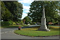
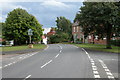
Road through Fladbury
Road through the village of Fladbury with the war memorial on the right.
Image: © Philip Halling
Taken: 22 Aug 2010
0.05 miles
8
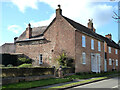
No. 4 The Green, Fladbury
Listed Grade II. An 18th century brick house with a new tile roof. No. 3 to its right is also Listed Grade II.
Image: © Chris Allen
Taken: 24 Feb 2022
0.05 miles
9
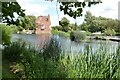
Cropthorne Mill
Cropthorne Mill viewed from the Fladbury side of the River Avon. There has been a mill here since the Domesday Book. This was a working mill until 1930. The village of Fladbury is on the far side of the river. The Mill is Grade II listed, see: https://historicengland.org.uk/listing/the-list/list-entry/1116926?section=official-list-entry
Image: © Philip Halling
Taken: 11 Aug 2023
0.05 miles
10
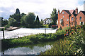
Cropthorne Mill
Cropthorne Mill viewed from the Fladbury side of the River Avon. There has been a mill here since the Domesday Book. This was a working mill until 1930. The village of Fladbury is on the far side of the river. The Mill is Grade II listed, see: https://historicengland.org.uk/listing/the-list/list-entry/1116926?section=official-list-entry
Image: © Philip Halling
Taken: 11 Aug 2023
0.05 miles