IMAGES TAKEN NEAR TO
Hill Furze Road, PERSHORE, WR10 2NU
Introduction
This page details the photographs taken nearby to Hill Furze Road, WR10 2NU by members of the Geograph project.
The Geograph project started in 2005 with the aim of publishing, organising and preserving representative images for every square kilometre of Great Britain, Ireland and the Isle of Man.

There are currently over 7.5m images from over14,400 individuals and you can help contribute to the project by visiting https://www.geograph.org.uk
Image Map (Loading...)


Getting Data...Please wait
Leaflet Map data © OpenStreetMap
Images are licensed for reuse under creativecommons.org/licenses/by-sa/2.0
Notes
- Clicking on the map will re-center to the selected point.
- The higher the marker number, the further away the image location is from the centre of the postcode.
Image Listing (5 Images Found)
Images are licensed for reuse under creativecommons.org/licenses/by-sa/2.0
Image
Details
Distance
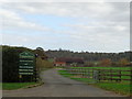
1
Converted farm buildings, Hill Furze
Badger's Hill can be seen in the background.
Image: © Philip Halling
Taken: 5 May 2007
0.05 miles
2
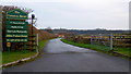
The Common Barns
Converted farm buildings off Hillfurze Road.
Image: © Jonathan Billinger
Taken: 3 Jan 2013
0.11 miles
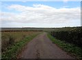
4
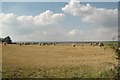
Hill Furze
Looking north-west towards Droitwich from the Fladbury to Bishampton Road
Image: © Dave Bushell
Taken: 20 Aug 2005
0.17 miles