IMAGES TAKEN NEAR TO
Throckmorton Road, PERSHORE, WR10 2JY
Introduction
This page details the photographs taken nearby to Throckmorton Road, WR10 2JY by members of the Geograph project.
The Geograph project started in 2005 with the aim of publishing, organising and preserving representative images for every square kilometre of Great Britain, Ireland and the Isle of Man.

There are currently over 7.5m images from over14,400 individuals and you can help contribute to the project by visiting https://www.geograph.org.uk
Image Map
Images are licensed for reuse under creativecommons.org/licenses/by-sa/2.0
Notes
- Clicking on the map will re-center to the selected point.
- The higher the marker number, the further away the image location is from the centre of the postcode.
Image Listing (7 Images Found)
Images are licensed for reuse under creativecommons.org/licenses/by-sa/2.0
Image
Details
Distance
1
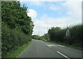
Throckmorton Road, Throckmorton near Vale Plants
Image: © Roy Hughes
Taken: 28 Aug 2021
0.03 miles
2
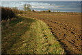
Field headland, Throckmorton
A footpath from Throckmorton to Hill follows the field headland.
Image: © Philip Halling
Taken: 22 Dec 2008
0.12 miles
3
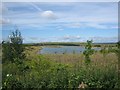
Lake at Hill
Lake created as part of land-fill development at Hill & Moor
Image: © Dave Bushell
Taken: 1 Sep 2005
0.14 miles
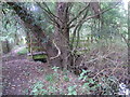
4
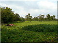
Old orchard land
Much mistletoe in these old cider apple trees near Throckmorton.
Image: © Jonathan Billinger
Taken: 30 Oct 2008
0.14 miles
5
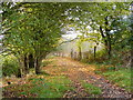
Autumnal footpath
The path leads west and then south towards Wyre Piddle, past a land-fill site and the Throckmorton Airfield. The former was used in 2001 as the main disposal site for farm animals in the Midlands during that year's outbreak of Foot and Mouth.
Image: © Jonathan Billinger
Taken: 30 Oct 2008
0.15 miles
6
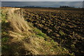
Headland and ploughed field, Throckmorton
Headland and a ploughed field to the south of Throckmorton.
Image: © Philip Halling
Taken: 22 Dec 2008
0.16 miles
7
Footbridge at path junction
Turning here takes the path across reclaimed land at Hill and Moor and between two lakes.
Image: © Liz Stone
Taken: 10 Sep 2012
0.17 miles