IMAGES TAKEN NEAR TO
Wyre Hill, PERSHORE, WR10 2HS
Introduction
This page details the photographs taken nearby to Wyre Hill, WR10 2HS by members of the Geograph project.
The Geograph project started in 2005 with the aim of publishing, organising and preserving representative images for every square kilometre of Great Britain, Ireland and the Isle of Man.

There are currently over 7.5m images from over14,400 individuals and you can help contribute to the project by visiting https://www.geograph.org.uk
Image Map (34 Images)


Leaflet Map data © OpenStreetMap
Images are licensed for reuse under creativecommons.org/licenses/by-sa/2.0
Notes
- Clicking on the map will re-center to the selected point.
- The higher the marker number, the further away the image location is from the centre of the postcode.
Image Listing (34 Images Found)
Images are licensed for reuse under creativecommons.org/licenses/by-sa/2.0
Image
Details
Distance
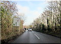
1
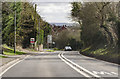
Wyre Hill
Towards Wyre Piddle. The road bends sharp right at the bottom.
Image: © J.Hannan-Briggs
Taken: 24 Feb 2017
0.05 miles
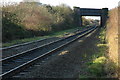
2
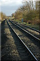
Railway line at Wyre Piddle
The Worcester to Oxford railway at Wyre Piddle, viewed here from the footpath crossing.
Image: © Philip Halling
Taken: 23 Nov 2008
0.09 miles
3
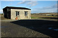
Shed at Wyre Piddle
This shed used for market gardening stands beside a footpath in Wyre Piddle, in the middle distance is the A44 Wyre Piddle bypass.
Image: © Philip Halling
Taken: 23 Nov 2008
0.10 miles
5
Railway bridge at Wyre Piddle
This bridge used to carry the A44 until the Wyre Piddle bypass was built, viewed here from a footpath crossing the Worcester to Oxford railway line.
Image: © Philip Halling
Taken: 23 Nov 2008
0.12 miles
6
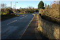
Road junction, Wyre Piddle
Until a few years ago when a bypass was built this road used to be the busy A44. The bridge in the foreground crosses Piddle Brook.
Image: © Philip Halling
Taken: 23 Nov 2008
0.13 miles
7
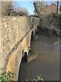
Wyre Bridge, Wyre Piddle
Across the Piddle Brook. Grade II Listed stone bridge that was rebuilt and widened in 1930. Very difficult to get a meaningful angle.
Image: © Chris Allen
Taken: 4 Jan 2022
0.13 miles
8
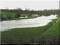
Overflowing Piddle
Piddle Brook and flooded land between the A44 (Wyre Piddle by-pass) and the railway line.
Image: © David Luther Thomas
Taken: 18 Jan 2007
0.13 miles
9
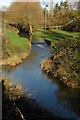
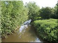
Piddle Brook, Wyre Piddle
Piddle Brook at Wyre Piddle viewed from the road bridge. In the background the embankment carrying the railway is just visible.
Image: © Philip Halling
Taken: 23 Nov 2008
0.14 miles