IMAGES TAKEN NEAR TO
Perry Place, WR10 2GE
Introduction
This page details the photographs taken nearby to Perry Place, WR10 2GE by members of the Geograph project.
The Geograph project started in 2005 with the aim of publishing, organising and preserving representative images for every square kilometre of Great Britain, Ireland and the Isle of Man.

There are currently over 7.5m images from over14,400 individuals and you can help contribute to the project by visiting https://www.geograph.org.uk
Image Map (Loading...)


Getting Data...Please wait
Leaflet Map data © OpenStreetMap
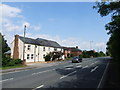
Images are licensed for reuse under creativecommons.org/licenses/by-sa/2.0
Notes
- Clicking on the map will re-center to the selected point.
- The higher the marker number, the further away the image location is from the centre of the postcode.
Image Listing (31 Images Found)
Images are licensed for reuse under creativecommons.org/licenses/by-sa/2.0
Image
Details
Distance

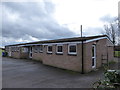
5
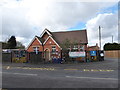
St Barnabas C of E First & Middle School
Image: © Basher Eyre
Taken: 6 Mar 2016
0.12 miles
8
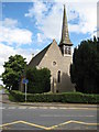
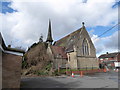
Drakes Broughton Church
Drakes Broughton church dates from 1857 and is dedicated to St Barnabas.
Image: © Philip Halling
Taken: 10 Aug 2008
0.13 miles
9
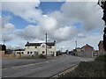
Junction of Stonebow Road and Walcot Lane
Image: © Basher Eyre
Taken: 6 Mar 2016
0.13 miles
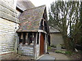
10
St. Barnabas, Drakes Broughton: early March 2016
Image: © Basher Eyre
Taken: 6 Mar 2016
0.13 miles