IMAGES TAKEN NEAR TO
Norchard Lane, PERSHORE, WR10 2EB
Introduction
This page details the photographs taken nearby to Norchard Lane, WR10 2EB by members of the Geograph project.
The Geograph project started in 2005 with the aim of publishing, organising and preserving representative images for every square kilometre of Great Britain, Ireland and the Isle of Man.

There are currently over 7.5m images from over14,400 individuals and you can help contribute to the project by visiting https://www.geograph.org.uk
Image Map (Loading...)


Getting Data...Please wait
Leaflet Map data © OpenStreetMap
Images are licensed for reuse under creativecommons.org/licenses/by-sa/2.0
Notes
- Clicking on the map will re-center to the selected point.
- The higher the marker number, the further away the image location is from the centre of the postcode.
Image Listing (32 Images Found)
Images are licensed for reuse under creativecommons.org/licenses/by-sa/2.0
Image
Details
Distance
1
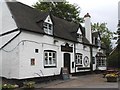
Crown Inn in summer
A wonderful 'Olde Worlde' pub.
Image: © Row17
Taken: 27 May 2002
0.01 miles
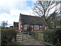
3
Orchard Cottage, Peopleton
A 17th century timber framed cottage with whitened brick nogging. Two storeys with a tile roof and gable ends. Listed Grade II.
Image: © Chris Allen
Taken: 7 Sep 2022
0.07 miles
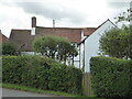
9
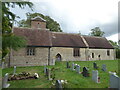
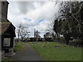
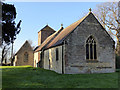
The Church of St Nicholas, Peopleton
Listed Grade II(star) and dating in part (chancel) to the 13th century.
Image: © Chris Allen
Taken: 7 Sep 2022
0.08 miles
10
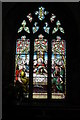
East window, Peopleton Church
The stained-glass east window of St Nicholas church, Peopleton.
Image: © Philip Halling
Taken: 25 Apr 2009
0.08 miles