IMAGES TAKEN NEAR TO
Peopleton, PERSHORE, WR10 2DZ
Introduction
This page details the photographs taken nearby to WR10 2DZ by members of the Geograph project.
The Geograph project started in 2005 with the aim of publishing, organising and preserving representative images for every square kilometre of Great Britain, Ireland and the Isle of Man.

There are currently over 7.5m images from over14,400 individuals and you can help contribute to the project by visiting https://www.geograph.org.uk
Image Map (Loading...)


Getting Data...Please wait
Leaflet Map data © OpenStreetMap
Images are licensed for reuse under creativecommons.org/licenses/by-sa/2.0
Notes
- Clicking on the map will re-center to the selected point.
- The higher the marker number, the further away the image location is from the centre of the postcode.
Image Listing (16 Images Found)
Images are licensed for reuse under creativecommons.org/licenses/by-sa/2.0
Image
Details
Distance
1
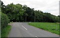
Road south from Peopleton to Stonebow
Image: © Andrew Tatlow
Taken: 16 Jul 2020
0.14 miles
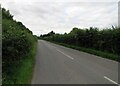
2

Public footpath towards Pinvin
The public bridleway signposted to the left follows the driveway to Hallgarth House.
See Image for the sign.
Image: © Andrew Tatlow
Taken: 16 Jul 2020
0.14 miles
3

Signpost for Public Footpath and Public Bridleway
The Public footpath goes towards Pinvin. The public bridleway signposted to the left follows the driveway to Hallgarth House and continues eastwards.
See Image for the general view.
Image: © Andrew Tatlow
Taken: 16 Jul 2020
0.14 miles
4

Wood Farm sign
See Image for the whole gateway.
Image: © Andrew Tatlow
Taken: 16 Jul 2020
0.15 miles
5

Entrance to Wood Farm
See Image for the name plate.
Image: © Andrew Tatlow
Taken: 16 Jul 2020
0.15 miles
7
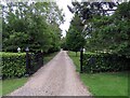
Driveway to Hallgarth House and Public Bridleway
The public bridleway signposted to the left follows the driveway to Hallgarth House and continues eastwards.
See Image for name plate.
Image: © Andrew Tatlow
Taken: 16 Jul 2020
0.18 miles
8

Hallgarth House sign
See Image for the whole gateway.
Image: © Andrew Tatlow
Taken: 16 Jul 2020
0.18 miles
9

NEW
Stone Arrow Farm
The wording (on the white sign) relates to a long-running dispute between the owner and the local council.
Image: © Mike Dodman
Taken: 20 May 2025
0.20 miles
10
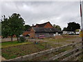
Stone Arrow Farm, Near Peopleton, Worcestershire
Image: © Jeff Gogarty
Taken: 5 Aug 2020
0.21 miles