IMAGES TAKEN NEAR TO
Station Road, PERSHORE, WR10 2BZ
Introduction
This page details the photographs taken nearby to Station Road, WR10 2BZ by members of the Geograph project.
The Geograph project started in 2005 with the aim of publishing, organising and preserving representative images for every square kilometre of Great Britain, Ireland and the Isle of Man.

There are currently over 7.5m images from over14,400 individuals and you can help contribute to the project by visiting https://www.geograph.org.uk
Image Map (Loading...)


Getting Data...Please wait
Leaflet Map data © OpenStreetMap
Images are licensed for reuse under creativecommons.org/licenses/by-sa/2.0
Notes
- Clicking on the map will re-center to the selected point.
- The higher the marker number, the further away the image location is from the centre of the postcode.
Image Listing (90 Images Found)
Images are licensed for reuse under creativecommons.org/licenses/by-sa/2.0
Image
Details
Distance
1
Industrial buildings, Pinvin
Industrial buildings belonging to Allen Gears in Pinvin.
Image: © Philip Halling
Taken: 23 Nov 2008
0.02 miles
2
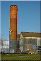
Chimney at Pinvin
A red-brick chimney, complete with security cameras, on an industrial site at Pinvin.
Image: © Philip Halling
Taken: 23 Nov 2008
0.02 miles
4
Allen Gears, Pershore
A large engineering company specialising in gears. According to the company website - Allen Gears are world leaders in the design and manufacture of epicyclic, parallel shaft and combination gearing and gearboxes in the power range 1-60MW. World leaders in the power generation industry, we specialise in providing high quality speed increasing and speed decreasing solutions for generator, pump and compressor drives for the Power Generation, Oil & Gas and Marine market sectors.
The works is Atlas Works. The company was originally a brank of W H Allen Sons & Co Ltd of Bedford. In 2014 the company was acquired by GE Oil and Gas for its Texas based Lufkin business.
Image: © Chris Allen
Taken: 26 Oct 2020
0.04 miles
5
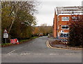
Walcot Lane, Pershore
Viewed across Station Road. Permanent signs show Ford 300 yds (ahead) and Road liable to flooding.
A white on red temporary sign shows ROAD CLOSED AHEAD.
Image: © Jaggery
Taken: 16 Nov 2014
0.05 miles
6
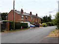
Houses on Walcot Lane
A row of houses on Walcot Lane at Pinvin.
Image: © David Dixon
Taken: 26 Jun 2017
0.05 miles
7
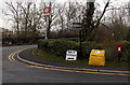
Pershore railway station name sign
The sign is on the corner of Station Road and Terrace Road. The station is not handily placed for the town centre. It is located beyond the northern boundary of Pershore, nearly 3km from the Abbey.
Image: © Jaggery
Taken: 16 Nov 2014
0.06 miles
8
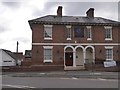
Day nursery near Pershore station
This building lies on a gridline. It was formerly the Coventry Arms inn, and was converted early in the 21st century into a day nursery, currently Bright Beginnings.
Image: © David Smith
Taken: 8 Oct 2016
0.07 miles

10
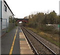
Yellow line along Pershore railway station platform
Keep to the left of the line to minimise the effects of air turbulence created by a train
passing through the station at high speed. Terrace Road bridge http://www.geograph.org.uk/photo/4313346 is in the background.
Image: © Jaggery
Taken: 16 Nov 2014
0.07 miles