IMAGES TAKEN NEAR TO
King Georges Way, PERSHORE, WR10 1QU
Introduction
This page details the photographs taken nearby to King Georges Way, WR10 1QU by members of the Geograph project.
The Geograph project started in 2005 with the aim of publishing, organising and preserving representative images for every square kilometre of Great Britain, Ireland and the Isle of Man.

There are currently over 7.5m images from over14,400 individuals and you can help contribute to the project by visiting https://www.geograph.org.uk
Image Map
Images are licensed for reuse under creativecommons.org/licenses/by-sa/2.0
Notes
- Clicking on the map will re-center to the selected point.
- The higher the marker number, the further away the image location is from the centre of the postcode.
Image Listing (605 Images Found)
Images are licensed for reuse under creativecommons.org/licenses/by-sa/2.0
Image
Details
Distance
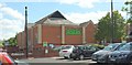
1
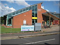
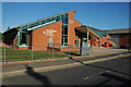
Pershore Leisure Centre
Modern sports centre and swimming pool built in the early 2000s
Image: © Philip Halling
Taken: 28 Jun 2012
0.01 miles
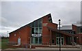
3
Pershore Leisure Centre
From the car park at Asda, across King George's Way; see also http://www.geograph.org.uk/search.php?i=73449998 . The building is powered by a hydropower generator using water from the River Avon. " To produce enough energy to power the centre the generator must create 750,000KW hours a year, which is its estimated output. This is done by two 15 tonne turbines converting 20 tonnes of water into power as it falls down a 2.4 metre head in the river" http://www.eveshamjournal.co.uk/news/11513765.Celebrations_as_ground_breaking_project_meets_green_target/ .
Image: © Derek Harper
Taken: 1 Jul 2017
0.02 miles
4
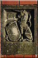
King George's Field, Pershore
Coat of arms on a gate post at the entrance to King George's Field in Pershore.
Image: © Philip Halling
Taken: 23 Nov 2008
0.02 miles
5
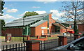
Pershore Leisure Centre
This leisure complex opened in 2002 replacing an earlier building. The building is quite near the River Avon and succumbed to the summer flood in July 2007, see: http://www.geograph.org.uk/photo/510883
Image: © Philip Halling
Taken: 1 May 2007
0.02 miles
6
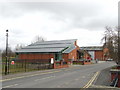
Pershore - Pershore Leisure Centre
Pershore Leisure Centre near the River Avon can be subject to flooding in extreme conditions.
Image: © Lewis Clarke
Taken: 21 Nov 2010
0.04 miles
7
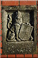
Coat of arms on a gate post, Pershore
Coat of arms of George V on a gate post at the entrance to King George's Field in Pershore.
Image: © Philip Halling
Taken: 23 Nov 2008
0.04 miles
8
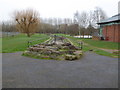
Looking towards the River Avon, Pershore
This open concrete drainage channel runs down to the River Avon. Pershore Leisure Centre is visible on the right. The edge of the football ground is just seen on the left. There is some flooding of the field by the leisure centre where two swans can be seen.
Image: © Chris Allen
Taken: 19 Feb 2020
0.04 miles
9
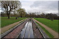
Pershore : Drainage Channel
Drainage channel through King George's Field taking excess water to the River Avon.
Image: © Lewis Clarke
Taken: 21 Nov 2010
0.04 miles
10
Asda, Pershore
From the same spot as Image], looking right across the car park.
Image: © Derek Harper
Taken: 1 Jul 2017
0.04 miles