1
Wyre Road (B4083), Pershore
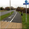
Viewed from the corner of the A4104 Station Road in the north of Pershore. This is the southwest end of the B4083, a short B road which extends for about 2km to Pinvin via Wyre Piddle.
Image: © Jaggery
Taken: 16 Nov 2014
0.07 miles
2
Building site on Wyre Road
Building site on Wyre Road, the B4083 on the northern edge of Pershore.
Image: © Philip Halling
Taken: 7 Jun 2017
0.09 miles
3
Corner of Wyre Road and Station Road, Pershore
Viewed from Station Road looking towards Wyre Road. http://www.geograph.org.uk/photo/4716824
Image: © Jaggery
Taken: 16 Nov 2014
0.09 miles
4
Houses on the north side of Mill Lane, Pershore
Viewed from the corner of Station Road.
Image: © Jaggery
Taken: 16 Nov 2014
0.09 miles
5
Building site beside the B4083
Houses being built beside the B4083 just off Station Road on the northern edge of Pershore.
Image: © Philip Halling
Taken: 7 Jun 2017
0.09 miles
6
Field edge footpath on the outskirts of Peshore heading for Wheelgate and the River Avon
Looking south-eastward.
Image: © Peter Wood
Taken: 7 Nov 2017
0.09 miles
7
Houses on the south side of Mill Lane, Pershore
Viewed from the corner of Station Road.
Image: © Jaggery
Taken: 16 Nov 2014
0.10 miles
8
Junction of Wyre Road and Station Road, Pershore
Junction of the B4083 (Wyre Road) with the A4104 (Station Road) to the north of Pershore.
Image: © Philip Halling
Taken: 23 Nov 2008
0.10 miles
9
Wyre Road/Station Road junction
Image: © Colin Pyle
Taken: 19 Sep 2010
0.11 miles
10
Half-a-mile to Pershore railway station
Combined footpath and cycleway on the east side of the A4104 Station Road.
Pershore railway station is not in the town of Pershore, but to the north in the village of Pinvin.
The centre of Pershore (the Abbey) is nearly 3km (about 2 miles) south of the station.
Image: © Jaggery
Taken: 16 Nov 2014
0.11 miles


