IMAGES TAKEN NEAR TO
Station Road, PERSHORE, WR10 1PG
Introduction
This page details the photographs taken nearby to Station Road, WR10 1PG by members of the Geograph project.
The Geograph project started in 2005 with the aim of publishing, organising and preserving representative images for every square kilometre of Great Britain, Ireland and the Isle of Man.

There are currently over 7.5m images from over14,400 individuals and you can help contribute to the project by visiting https://www.geograph.org.uk
Image Map (Loading...)


Getting Data...Please wait
Leaflet Map data © OpenStreetMap
Images are licensed for reuse under creativecommons.org/licenses/by-sa/2.0
Notes
- Clicking on the map will re-center to the selected point.
- The higher the marker number, the further away the image location is from the centre of the postcode.
Image Listing (44 Images Found)
Images are licensed for reuse under creativecommons.org/licenses/by-sa/2.0
Image
Details
Distance
1
Pershore Fireworks office
Located in The Old Surgery, The Croft, Station Road.
Image: © Jaggery
Taken: 16 Nov 2014
0.01 miles
2
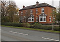
Obsolete council notice, Pershore
On the east side of Station Road, viewed in November 2014. The fading notice was issued by the County Council of Hereford and Worcester, which was created on April 1st 1974 following the Local Government Act 1972.
The new county included the former administrative county of Herefordshire and most of Worcestershire (except Halesowen, Stourbridge and Warley, which became part of the West Midlands, and the County Borough of Worcester).
The intention was to increase local government efficiency, since the two counties were among England's smaller and least populous counties, particularly after the same act moved some of Worcestershire's most urbanised areas to the West Midlands. Predictably, it aroused much resentment and opposition in Herefordshire, which regarded it as a takeover by Worcestershire.
The County Council of Hereford and Worcester was abolished in 1998 and reverted, with some border adjustments, to the two separate historic counties of Herefordshire and Worcestershire.
Image: © Jaggery
Taken: 16 Nov 2014
0.05 miles
3
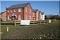
New houses on Wyre Meadow
New houses on the Wyre Meadon housing development at Pershore.
Image: © Philip Halling
Taken: 25 Mar 2016
0.06 miles
4
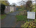
Building site on Wyre Road
Building site on Wyre Road, the B4083 on the northern edge of Pershore.
Image: © Philip Halling
Taken: 7 Jun 2017
0.07 miles
5
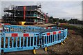
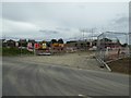
Building site, Station Road
Building site which is being named Wyre Meadow and is on Station Road, Pershore.
Image: © Philip Halling
Taken: 22 Aug 2015
0.07 miles
6
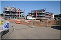
Construction on Wrye Meadow
Work is now well underway on this building site on Station Road, Pershore.
Image: © Philip Halling
Taken: 6 Sep 2015
0.07 miles
7
Building site beside the B4083
Houses being built beside the B4083 just off Station Road on the northern edge of Pershore.
Image: © Philip Halling
Taken: 7 Jun 2017
0.08 miles
8
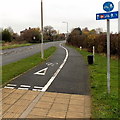
Half-a-mile to Pershore railway station
Combined footpath and cycleway on the east side of the A4104 Station Road.
Pershore railway station is not in the town of Pershore, but to the north in the village of Pinvin.
The centre of Pershore (the Abbey) is nearly 3km (about 2 miles) south of the station.
Image: © Jaggery
Taken: 16 Nov 2014
0.08 miles
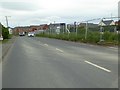
9
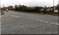
Junction in the north of Pershore
Junction of Station Road and Wyre Road. Turn left into Station Road for Pershore town centre or right for Pershore railway station and Worcester. The B4083 Wyre Road behind the camera leads to Wyre Piddle.
Image: © Jaggery
Taken: 16 Nov 2014
0.09 miles
10
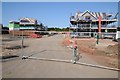
Wyre Meadow, Pershore
Work is now well underway on this building site on Station Road, Pershore.
Image: © Philip Halling
Taken: 6 Sep 2015
0.09 miles