IMAGES TAKEN NEAR TO
Abbey Road, PERSHORE, WR10 1JT
Introduction
This page details the photographs taken nearby to Abbey Road, WR10 1JT by members of the Geograph project.
The Geograph project started in 2005 with the aim of publishing, organising and preserving representative images for every square kilometre of Great Britain, Ireland and the Isle of Man.

There are currently over 7.5m images from over14,400 individuals and you can help contribute to the project by visiting https://www.geograph.org.uk
Image Map (75 Images)


Leaflet Map data © OpenStreetMap
Images are licensed for reuse under creativecommons.org/licenses/by-sa/2.0
Notes
- Clicking on the map will re-center to the selected point.
- The higher the marker number, the further away the image location is from the centre of the postcode.
Image Listing (75 Images Found)
Images are licensed for reuse under creativecommons.org/licenses/by-sa/2.0
Image
Details
Distance
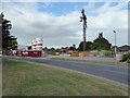
1
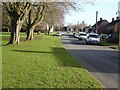
St Andrew's Road
St Andrew's Road beside Abbey Park.
Image: © Philip Halling
Taken: 30 Jan 2022
0.06 miles
2
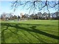
Abbey Park
Abbey Park with the tower of Pershore Abbey visible in the background.
Image: © Philip Halling
Taken: 30 Jan 2022
0.07 miles
3
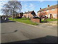
Houses on Farleigh Road
Houses, probably built in the 1950s, on Farleigh Road in Pershore.
Image: © Philip Halling
Taken: 30 Jan 2022
0.07 miles
4
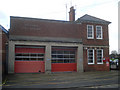
Pershore Fire Station
On the west side of Defford Road.
Image: © Trevor Rickard
Taken: 1 Dec 2008
0.09 miles
5
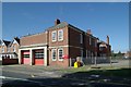
Pershore fire station
Pershore fire station, Defford Road, Pershore, Worcestershire.
Image: © Kevin Hale
Taken: 6 Aug 2006
0.10 miles
6
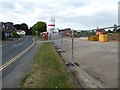
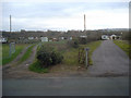
Redevelopment site on Defford Road, Pershore
This site on Defford Road in Pershore used to be the site of the hospital Image] which closed some years ago; it is now being redeveloped with a Churchill retirement home being built on the site.
Image: © Philip Halling
Taken: 25 Jul 2016
0.12 miles
7
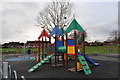
Pershore : Abbey Park Play Area
Children playing on a quiet Sunday in Abbey Park.
Image: © Lewis Clarke
Taken: 21 Nov 2010
0.12 miles
8
Redevelopment site in Pershore
This site on Defford Road in Pershore used to be the site of the hospital Image] which closed some years ago; it is now being redeveloped with a Churchill retirement home being built on the site.
Image: © Philip Halling
Taken: 25 Jul 2016
0.13 miles
9
Allotments off Defford Road
Large allotment site on the south side of the road. The appropriately-named 'Bredon View' on the right with Bredon Hill beyond.
Image: © Trevor Rickard
Taken: 1 Dec 2008
0.13 miles
10

Pershore : Abbey Park Water Play Area
Used in the summer for a bit of fun in the fountains.
Image: © Lewis Clarke
Taken: 21 Nov 2010
0.14 miles