IMAGES TAKEN NEAR TO
Masons Ryde, PERSHORE, WR10 1JG
Introduction
This page details the photographs taken nearby to Masons Ryde, WR10 1JG by members of the Geograph project.
The Geograph project started in 2005 with the aim of publishing, organising and preserving representative images for every square kilometre of Great Britain, Ireland and the Isle of Man.

There are currently over 7.5m images from over14,400 individuals and you can help contribute to the project by visiting https://www.geograph.org.uk
Image Map (Loading...)


Getting Data...Please wait
Leaflet Map data © OpenStreetMap
Images are licensed for reuse under creativecommons.org/licenses/by-sa/2.0
Notes
- Clicking on the map will re-center to the selected point.
- The higher the marker number, the further away the image location is from the centre of the postcode.
Image Listing (656 Images Found)
Images are licensed for reuse under creativecommons.org/licenses/by-sa/2.0
Image
Details
Distance
1
Pershore Baptist Church
Located in Broad Street, the Church's website is here http://www.pershorebaptist.org/
Image: © Nigel Cox
Taken: 21 Jun 2008
0.02 miles
2
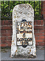
Old Milestone by the B4536, Abbey Park, Pershore parish
Metal plate attached to stone post by the B4536 (loop), in parish of PERSHORE (WYCHAVON District), Abbey Park, just South of Broad Street, by housing estate called 'The Milestone', set in pavement, on East side of road. Erected by the Evesham Second District turnpike trust in the 18th century.
Inscription reads:-
: UPTON / 8 Miles / Evefham / 6 / LONDON / 102 :
Milestone Society National ID: WO_USEV08.
Image: © J Higgins
Taken: 4 Oct 2008
0.03 miles
3
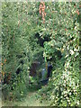
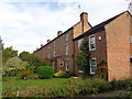
Path at back of Masons Ryde, Pershore, Worcestershire
Image: © Jeff Gogarty
Taken: 24 Sep 2016
0.04 miles
4
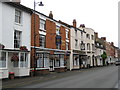
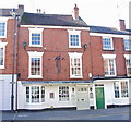
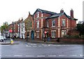
Pershore: The Star Inn and The Brandy Cask pub & brewery
These two pubs stand next to one another in Pershore's Georgian Bridge Street.
The Brandy Cask, which is a Grade II listed building, was recently threatened with conversion into a residential property. The brewery is in the back yard and produces Whistling Joe (ABV 3.6%), Brandy Snapper (ABV 4.0%), John Baker’s Original (ABV 4.8%), and the punningly named Ale Mary (ABV 4.8%).
The Star Inn used to be the Coach and Horses until that mode of transport died out. Its website is here http://www.thestarinnpershore.com/
Image: © Nigel Cox
Taken: 21 Jun 2008
0.04 miles
5
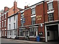
The Star Inn, Bridge Street, Pershore, Worcs
Image: © Ann Causer
Taken: Unknown
0.04 miles
7
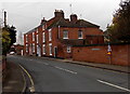
Northern end of Defford Road, Pershore
The B4536 Defford Road heads south away from the corner of Broad Street. http://www.geograph.org.uk/photo/4247409
Image: © Jaggery
Taken: 16 Nov 2014
0.04 miles
8
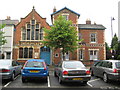
Pershore Baptist church
Located on the south side of Broad Street.
Image: © Jonathan Billinger
Taken: 23 Sep 2009
0.05 miles
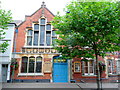
9
Pershore Baptist Church, Broad Street
The actual chapel, which was built in 1839-40, is behind the Victorian buildings seen in this view, all of which form part of the church complex. The buildings that can be seen from the road are quite striking, with patterned brickwork.
Image: © P L Chadwick
Taken: 26 Nov 2009
0.05 miles