IMAGES TAKEN NEAR TO
Bagshaw Court, Worcester Road, PERSHORE, WR10 1HB
Introduction
This page details the photographs taken nearby to Bagshaw Court, Worcester Road, WR10 1HB by members of the Geograph project.
The Geograph project started in 2005 with the aim of publishing, organising and preserving representative images for every square kilometre of Great Britain, Ireland and the Isle of Man.

There are currently over 7.5m images from over14,400 individuals and you can help contribute to the project by visiting https://www.geograph.org.uk
Image Map (Loading...)


Getting Data...Please wait
Leaflet Map data © OpenStreetMap
Images are licensed for reuse under creativecommons.org/licenses/by-sa/2.0
Notes
- Clicking on the map will re-center to the selected point.
- The higher the marker number, the further away the image location is from the centre of the postcode.
Image Listing (205 Images Found)
Images are licensed for reuse under creativecommons.org/licenses/by-sa/2.0
Image
Details
Distance
1
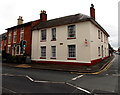
The Vineyards, Pershore
The Vineyards is at 63 Head Street, on the corner of High Street (on the left). The building has been converted to self-contained housing units. A notice on the wall shows BEDSIT TO LET.
Image: © Jaggery
Taken: 16 Nov 2014
0.01 miles
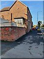
2
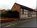
Grade II listed former barn in Pershore
At the northern end of Head Street near the High Street junction. The square-panel timber frame building formerly had an entrance on this side, now blocked off. An unusual survival so near High Street, the building was Grade II Listed in 1998.
Image: © Jaggery
Taken: 16 Nov 2014
0.01 miles
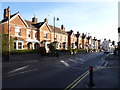
3
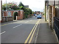
Head Street in Pershore
Looking south-westward.
Image: © Peter Wood
Taken: 15 Apr 2017
0.01 miles
4
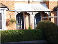
Doorways of 155/157 High Street, Persore
These are the leftmost house in Image
Image: © Jeff Gogarty
Taken: 28 Jan 2020
0.02 miles
5
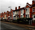
High Street houses, Pershore
Near the NW end of High Street, about 500 metres from its SE end.
Image: © Jaggery
Taken: 16 Nov 2014
0.02 miles
8
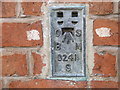
Ordnance Survey Flush Bracket S0241
This bracket can be found on the roadside wall of a building in Worcester Road, Pershore.
For more detail see : http://www.bench-marks.org.uk/bm18860
Image: © Peter Wood
Taken: 15 Apr 2017
0.02 miles
9
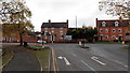
Junction at the southern end of Station Road, Pershore
Left for High Street, the town centre and the road to Evesham, right for the road to Worcester.
Image: © Jaggery
Taken: 16 Nov 2014
0.02 miles
10
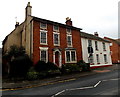
Grade II listed St Margarets, Pershore
The red brick house at 154 High Street dates from c1800. Grade II listed in 1972.
Image: © Jaggery
Taken: 16 Nov 2014
0.02 miles