IMAGES TAKEN NEAR TO
High Street, PERSHORE, WR10 1EQ
Introduction
This page details the photographs taken nearby to High Street, WR10 1EQ by members of the Geograph project.
The Geograph project started in 2005 with the aim of publishing, organising and preserving representative images for every square kilometre of Great Britain, Ireland and the Isle of Man.

There are currently over 7.5m images from over14,400 individuals and you can help contribute to the project by visiting https://www.geograph.org.uk
Image Map (Loading...)


Getting Data...Please wait
Leaflet Map data © OpenStreetMap
Images are licensed for reuse under creativecommons.org/licenses/by-sa/2.0
Notes
- Clicking on the map will re-center to the selected point.
- The higher the marker number, the further away the image location is from the centre of the postcode.
Image Listing (466 Images Found)
Images are licensed for reuse under creativecommons.org/licenses/by-sa/2.0
Image
Details
Distance
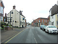
2
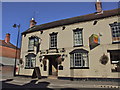
The Plough Inn, 135 High Street
Situated towards the western end of the High Street, this is one of Pershore's many surviving inns and pubs. The recessed area on the right looks as if it might at one time have been the street entrance to a passageway to the back of the building; possibly for horses? The inn does not seem to have a traditional sign. Photograph taken from Priest Lane opposite.
Image: © P L Chadwick
Taken: 26 Nov 2009
0.01 miles
3
Oasis Dental Care in Pershore
Provider of NHS and private dental care at 133 High Street. Entrance is through the archway.
Image: © Jaggery
Taken: 16 Nov 2014
0.01 miles
4
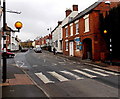
Zebra crossing, High Street, Pershore
Across High Street near the Priest Lane junction.
Although Belisha beacons had marked pedestrian crossings in the UK from 1934, it was not until 1951 that the now familiar black and white stripes stretching across the width of the road were officially introduced. Previously, there were only metal studs across the road surface. Modern zebra crossings have evolved from their 1950s predecessors - for example here the beacons have an outer ring of flashing amber LED (light emitting diode) lights. Because of their brightness and low electricity consumption, this type is replacing traditional incandescent bulbs in many areas.
Image: © Jaggery
Taken: 16 Nov 2014
0.01 miles
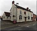
5
High Street passes The Plough Inn
This Grade II listed building has English Heritage Building ID: 474545. It dates from the late 16th - early 17th C. but was much rebuilt some 200 years later.
Image: © Stuart Logan
Taken: 12 May 2013
0.01 miles
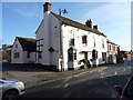
6
The Pickled Plum, Pershore
Formerly named The Plough Inn, http://www.geograph.org.uk/photo/2131266 the pub's new name is one of several in Pershore that include the word plum. Pershore is famous for the many plums grown locally. Every August, the town holds a Plum Festival which celebrates its fruit-growing heritage.
Image: © Jaggery
Taken: 16 Nov 2014
0.01 miles
7
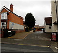
This way to the police station, hospital and council offices, Pershore
The path from High Street leads to Queen Elizabeth Drive. The edge of the Pickled Plum pub http://www.geograph.org.uk/photo/4249197 (formerly The Plough Inn) is on the right.
Image: © Jaggery
Taken: 16 Nov 2014
0.01 miles
8
The Pickled Plum, High Street, Pershore
Pershore is famous for its plums and have a plum festival every year.
Image: © Jeff Gogarty
Taken: 28 Jan 2020
0.02 miles
9
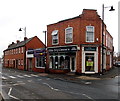
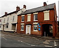
Elite Dry Cleaners in Pershore
On the corner of High Street (left) and Priest Lane. Financial House Independent Advisers is next door.
Image: © Jaggery
Taken: 16 Nov 2014
0.02 miles
10
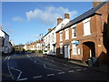
Pershore High Street heading out of town
Image: © Jeff Gogarty
Taken: 28 Jan 2020
0.02 miles