IMAGES TAKEN NEAR TO
Whitcroft Road, PERSHORE, WR10 1EN
Introduction
This page details the photographs taken nearby to Whitcroft Road, WR10 1EN by members of the Geograph project.
The Geograph project started in 2005 with the aim of publishing, organising and preserving representative images for every square kilometre of Great Britain, Ireland and the Isle of Man.

There are currently over 7.5m images from over14,400 individuals and you can help contribute to the project by visiting https://www.geograph.org.uk
Image Map (94 Images)


Getting Data...Please wait
Leaflet Map data © OpenStreetMap
Images are licensed for reuse under creativecommons.org/licenses/by-sa/2.0
Notes
- Clicking on the map will re-center to the selected point.
- The higher the marker number, the further away the image location is from the centre of the postcode.
Image Listing (94 Images Found)
Images are licensed for reuse under creativecommons.org/licenses/by-sa/2.0
Image
Details
Distance
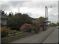
1
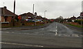
Whitcroft Road, Pershore
Looking ESE across Station Road.
Image: © Jaggery
Taken: 16 Nov 2014
0.03 miles
2
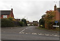
Nursery Close Pershore
Cul-de-sac on the SE side of Station Road.
Image: © Jaggery
Taken: 16 Nov 2014
0.04 miles

4
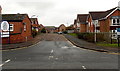
Queen Elizabeth Drive, Pershore
Viewed across Station Road. Queen Elizabeth Drive leads to Pershore hospital,
police station, civic centre and Wychavon District Council offices.
Image: © Jaggery
Taken: 16 Nov 2014
0.07 miles
5
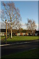
Bungalows beside Station Road, Pershore
Bungalows, possibly for the elderly beside Station Road to the north of the centre of Pershore.
Image: © Philip Halling
Taken: 23 Nov 2008
0.07 miles
6
Bus shelter, Station Road, Pershore
Sensibly, this shelter has been placed so as not to impede pedestrians
Image: © David Smith
Taken: 8 Oct 2016
0.07 miles
7
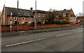
Station Road side of Queen Elizabeth Drive houses in Pershore
I was surprised that usually helpful reference sources do not give the original use of this Station Road building near the corner of Queen Elizabeth Drive, now in use as housing. Perhaps a former school?
Image: © Jaggery
Taken: 16 Nov 2014
0.08 miles
8
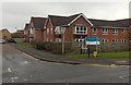
Heathlands Residential Care Home, Pershore
Purpose-built care home on the corner of Station Road and Queen Elizabeth Drive.
Image: © Jaggery
Taken: 16 Nov 2014
0.09 miles
9
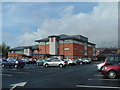
Pershore Hospital
The new Pershore Hospital which was opened by H.R.H Duchess of Gloucester on the 20th May 2007. This is a state of the art facility which replaces the cottage hospital.
Image: © Derek Bradley
Taken: 20 Sep 2007
0.09 miles
10
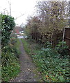
Path from Acorn Grove to Maple Avenue, Pershore
Looking towards Maple Avenue from the edge of the Acorn Grove turning area. http://www.geograph.org.uk/photo/4252955
Image: © Jaggery
Taken: 16 Nov 2014
0.11 miles