IMAGES TAKEN NEAR TO
Priest Lane, PERSHORE, WR10 1EB
Introduction
This page details the photographs taken nearby to Priest Lane, WR10 1EB by members of the Geograph project.
The Geograph project started in 2005 with the aim of publishing, organising and preserving representative images for every square kilometre of Great Britain, Ireland and the Isle of Man.

There are currently over 7.5m images from over14,400 individuals and you can help contribute to the project by visiting https://www.geograph.org.uk
Image Map (Loading...)


Getting Data...Please wait
Leaflet Map data © OpenStreetMap
Images are licensed for reuse under creativecommons.org/licenses/by-sa/2.0
Notes
- Clicking on the map will re-center to the selected point.
- The higher the marker number, the further away the image location is from the centre of the postcode.
Image Listing (590 Images Found)
Images are licensed for reuse under creativecommons.org/licenses/by-sa/2.0
Image
Details
Distance
1
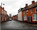
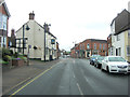
Priest Lane, Pershore
Looking south from High Street. Pershore Abbey is in the background.
Image: © Jaggery
Taken: 16 Nov 2014
0.01 miles
2
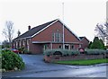
Holy Redeemer Roman Catholic Church, Priest Lane
Appropriately Pershore's Catholic church is to be found in Priest Lane, which no doubt got its name centuries ago from the nearby Pershore Abbey. The church was built in 1958-59 to the design of Hugh Bankart of Bath.
Image: © P L Chadwick
Taken: 26 Nov 2009
0.02 miles
3
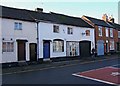
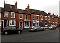
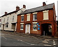
Former inn, High Street
The white building in the middle appears to be a former inn, as the black arched door on the right appears to be a carriage entrance. There is also a bracket above, from which presumably hung a sign. There also appears to be a carriage arch at the front of the building on the right. These buildings are near the traffic lights at the junction with Cherry Orchard.
There are a lot of buildings in Pershore with what appear to be former carriage entrances. Probably not all were inns; some may have been the premises of blacksmiths or farriers, or other businesses where horses or carriages needed to be taken through into an inner courtyard or stables.
Image: © P L Chadwick
Taken: 26 Nov 2009
0.03 miles
4
Hansen Chard Antiques in Pershore
Located in The Old Clock Shop at 126 High Street.
Echelon Cycles shop http://www.geograph.org.uk/photo/4248859 is on the left.
Image: © Jaggery
Taken: 16 Nov 2014
0.04 miles
5
Echelon Cycles in Pershore
Bicycle shop at 124 High Street.
Image: © Jaggery
Taken: 16 Nov 2014
0.04 miles
6
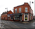
Elite Dry Cleaners in Pershore
On the corner of High Street (left) and Priest Lane. Financial House Independent Advisers is next door.
Image: © Jaggery
Taken: 16 Nov 2014
0.05 miles
7
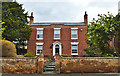
Hawthorns, 115 High Street, Pershore
A delightful early 19th century villa, laying back from the High Street. Like much of the town, it is listed Grade II.
Image: © Philip Pankhurst
Taken: 26 Mar 2016
0.05 miles
8
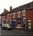
High Street (East Side) Pershore
This block of buildings are all Grade II listed buildings.
Image: © Jeff Gogarty
Taken: 28 Jan 2020
0.05 miles
9
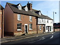
High Street passes The Plough Inn
This Grade II listed building has English Heritage Building ID: 474545. It dates from the late 16th - early 17th C. but was much rebuilt some 200 years later.
Image: © Stuart Logan
Taken: 12 May 2013
0.05 miles
10
Oasis Dental Care in Pershore
Provider of NHS and private dental care at 133 High Street. Entrance is through the archway.
Image: © Jaggery
Taken: 16 Nov 2014
0.06 miles