IMAGES TAKEN NEAR TO
Pimbo Road, SKELMERSDALE, WN8 9RB
Introduction
This page details the photographs taken nearby to Pimbo Road, WN8 9RB by members of the Geograph project.
The Geograph project started in 2005 with the aim of publishing, organising and preserving representative images for every square kilometre of Great Britain, Ireland and the Isle of Man.

There are currently over 7.5m images from over14,400 individuals and you can help contribute to the project by visiting https://www.geograph.org.uk
Image Map
Images are licensed for reuse under creativecommons.org/licenses/by-sa/2.0
Notes
- Clicking on the map will re-center to the selected point.
- The higher the marker number, the further away the image location is from the centre of the postcode.
Image Listing (7 Images Found)
Images are licensed for reuse under creativecommons.org/licenses/by-sa/2.0
Image
Details
Distance
1
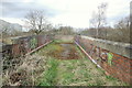
Bridge over railway, East Pimbo, Skelmersdale
Image: © Gary Rogers
Taken: 21 Mar 2014
0.07 miles
3
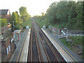
Upholland Station
Taken from the road bridge over the line looking west
Image: © Gary Rogers
Taken: 16 Jun 2005
0.16 miles
4
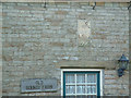
Date stone on Old Bounty Farmhouse
Showing dates of original construction and repairs.
Image: © Gary Rogers
Taken: 16 Jun 2005
0.16 miles
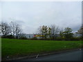
5
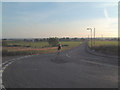
Millets
Looking west from the T junction towards Crawford
Image: © Gary Rogers
Taken: 16 Jun 2005
0.16 miles
6
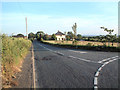
Millets
View south from the T junction. The road leads to Maddocks and Kings Moss.
Image: © Gary Rogers
Taken: 16 Jun 2005
0.16 miles
7

Bellis Flower in Dry Stone Wall
Wendy says it's a Single Dwarf Bellis! growing in a dry stone wall near Old Bounty Farm - Millets.
Image: © Gary Rogers
Taken: 16 Jun 2005
0.16 miles