IMAGES TAKEN NEAR TO
Pilling Place, SKELMERSDALE, WN8 9PF
Introduction
This page details the photographs taken nearby to Pilling Place, WN8 9PF by members of the Geograph project.
The Geograph project started in 2005 with the aim of publishing, organising and preserving representative images for every square kilometre of Great Britain, Ireland and the Isle of Man.

There are currently over 7.5m images from over14,400 individuals and you can help contribute to the project by visiting https://www.geograph.org.uk
Image Map
Images are licensed for reuse under creativecommons.org/licenses/by-sa/2.0
Notes
- Clicking on the map will re-center to the selected point.
- The higher the marker number, the further away the image location is from the centre of the postcode.
Image Listing (12 Images Found)
Images are licensed for reuse under creativecommons.org/licenses/by-sa/2.0
Image
Details
Distance
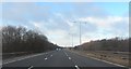
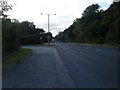
3
An entry onto the largest roundabout around
The one-way system around the West Pimbo Industrial Estate in Skelmersdale takes in four 1km squares.
Image: © David Long
Taken: 31 Dec 2005
0.17 miles

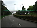
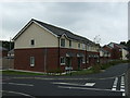
5
West Pimbo Industrial Estate, Pimbo Road
Image: © David Dixon
Taken: 19 Oct 2019
0.19 miles
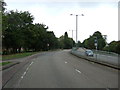
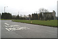
6
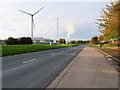
Pimbo Road
West Pimbo Industrial Estate.
Image: © David Dixon
Taken: 19 Oct 2019
0.19 miles