IMAGES TAKEN NEAR TO
Abbeystead, SKELMERSDALE, WN8 9NF
Introduction
This page details the photographs taken nearby to Abbeystead, WN8 9NF by members of the Geograph project.
The Geograph project started in 2005 with the aim of publishing, organising and preserving representative images for every square kilometre of Great Britain, Ireland and the Isle of Man.

There are currently over 7.5m images from over14,400 individuals and you can help contribute to the project by visiting https://www.geograph.org.uk
Image Map
Images are licensed for reuse under creativecommons.org/licenses/by-sa/2.0
Notes
- Clicking on the map will re-center to the selected point.
- The higher the marker number, the further away the image location is from the centre of the postcode.
Image Listing (19 Images Found)
Images are licensed for reuse under creativecommons.org/licenses/by-sa/2.0
Image
Details
Distance
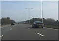
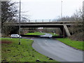
1

A bridge carrying the M58 catches the late afternoon sun
Image: © Ian Greig
Taken: 27 Nov 2010
0.11 miles
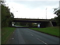
2
M58 motorway crossing Whiteledge Road
Image: © Peter Whatley
Taken: 23 Mar 2012
0.11 miles
3
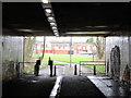
Subway under the M58 at West Pimbo looking towards Digmoor
Image: © Gary Rogers
Taken: 21 Feb 2016
0.11 miles
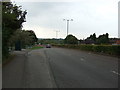
4
Footbridge over Whitelodge Road
Heading south.
Image: © JThomas
Taken: 13 Sep 2014
0.13 miles
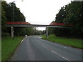
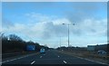
6
Where the M58 passes over Whiteledge Road
At the north west corner of Pimbo Industrial Estate. My car was parked at what looks on the map as if it should be the start of a public footpath but at the time of my visit access was well and truly fenced and gated off.
Image: © Gary Rogers
Taken: 21 Feb 2016
0.13 miles
7
M58 motorway over Whitelodge Farm
Heading south.
Image: © JThomas
Taken: 13 Sep 2014
0.13 miles
10
Approaching Thorn Island
Heading west on Gillbrands Road.
Image: © JThomas
Taken: 13 Sep 2014
0.16 miles