IMAGES TAKEN NEAR TO
Colinton, SKELMERSDALE, WN8 9AB
Introduction
This page details the photographs taken nearby to Colinton, WN8 9AB by members of the Geograph project.
The Geograph project started in 2005 with the aim of publishing, organising and preserving representative images for every square kilometre of Great Britain, Ireland and the Isle of Man.

There are currently over 7.5m images from over14,400 individuals and you can help contribute to the project by visiting https://www.geograph.org.uk
Image Map
Images are licensed for reuse under creativecommons.org/licenses/by-sa/2.0
Notes
- Clicking on the map will re-center to the selected point.
- The higher the marker number, the further away the image location is from the centre of the postcode.
Image Listing (7 Images Found)
Images are licensed for reuse under creativecommons.org/licenses/by-sa/2.0
Image
Details
Distance
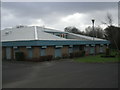
3
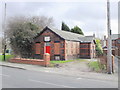
Upholland Moor Social Club, Ormskirk Road
Image: © Gary Rogers
Taken: 22 Feb 2016
0.19 miles
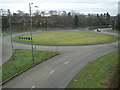
4
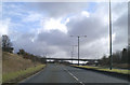
Ne'er the twain shall meet
Skelmersdale's traffic system is aimed at keeping vehicles and pedestrians apart, leading to loads of footbridges, and no roadside pavements.
Image: © David Long
Taken: 17 Feb 2006
0.21 miles
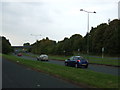
5
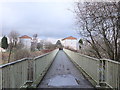
Footbridge over Grimshaw Road leading to Tanhouse
Image: © Gary Rogers
Taken: 22 Feb 2016
0.23 miles