IMAGES TAKEN NEAR TO
Thurston, SKELMERSDALE, WN8 8QX
Introduction
This page details the photographs taken nearby to Thurston, WN8 8QX by members of the Geograph project.
The Geograph project started in 2005 with the aim of publishing, organising and preserving representative images for every square kilometre of Great Britain, Ireland and the Isle of Man.

There are currently over 7.5m images from over14,400 individuals and you can help contribute to the project by visiting https://www.geograph.org.uk
Image Map
Images are licensed for reuse under creativecommons.org/licenses/by-sa/2.0
Notes
- Clicking on the map will re-center to the selected point.
- The higher the marker number, the further away the image location is from the centre of the postcode.
Image Listing (13 Images Found)
Images are licensed for reuse under creativecommons.org/licenses/by-sa/2.0
Image
Details
Distance
1
Exception to the rule
A pavement, and housing within reach of the Ring Road around Skelmersdale at the Stanley Roundabout.
Image: © David Long
Taken: 17 Feb 2006
0.13 miles
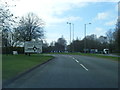
2
Roundabout in Skelmersdale
One of many roundabouts in Skelmersdale, and it famously has no traffic lights. This one may be called Chapel House Island.
Image: © Bill Boaden
Taken: 4 May 2013
0.14 miles
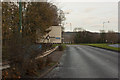
4
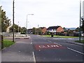
School Lane crosses Kiln Lane in Skelmersdale
Image: © Raymond Knapman
Taken: 22 Sep 2010
0.15 miles
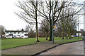
5
Path between Milrose Close and Berry Street, Skelmersdale
Image: © Gary Rogers
Taken: 5 Mar 2016
0.15 miles
6
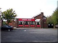
The Busy Bee on Kiln Lane, Skelmersdale
Image: © Raymond Knapman
Taken: 22 Sep 2010
0.16 miles
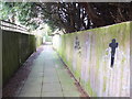
7
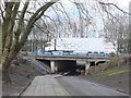
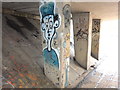
Subway under Neverstitch Road leading to Stanley, Skelmersdale
Image: © Gary Rogers
Taken: 5 Mar 2016
0.16 miles
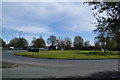
8
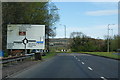
Approaching Halfmile Island
The roundabout ahead is reputed to be the second largest in Europe.
Image: © Bill Boaden
Taken: 4 May 2013
0.17 miles