IMAGES TAKEN NEAR TO
Windrows, SKELMERSDALE, WN8 8NW
Introduction
This page details the photographs taken nearby to Windrows, WN8 8NW by members of the Geograph project.
The Geograph project started in 2005 with the aim of publishing, organising and preserving representative images for every square kilometre of Great Britain, Ireland and the Isle of Man.

There are currently over 7.5m images from over14,400 individuals and you can help contribute to the project by visiting https://www.geograph.org.uk
Image Map
Images are licensed for reuse under creativecommons.org/licenses/by-sa/2.0
Notes
- Clicking on the map will re-center to the selected point.
- The higher the marker number, the further away the image location is from the centre of the postcode.
Image Listing (9 Images Found)
Images are licensed for reuse under creativecommons.org/licenses/by-sa/2.0
Image
Details
Distance
6
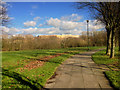
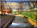
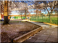
Footpath Through Tawd Valley Park
Footpath towards Skelmersdale town centre, through Tawd Valley Park.
Image: © David Dixon
Taken: 10 Feb 2016
0.15 miles

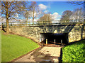
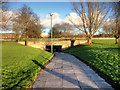
9

Sculpture on Hope Island
The Marie Curie Hope Island is the home of the Gateway artwork.
Image: © Mat Fascione
Taken: 27 Jun 2016
0.23 miles