IMAGES TAKEN NEAR TO
School Lane, SKELMERSDALE, WN8 8EH
Introduction
This page details the photographs taken nearby to School Lane, WN8 8EH by members of the Geograph project.
The Geograph project started in 2005 with the aim of publishing, organising and preserving representative images for every square kilometre of Great Britain, Ireland and the Isle of Man.

There are currently over 7.5m images from over14,400 individuals and you can help contribute to the project by visiting https://www.geograph.org.uk
Image Map
Images are licensed for reuse under creativecommons.org/licenses/by-sa/2.0
Notes
- Clicking on the map will re-center to the selected point.
- The higher the marker number, the further away the image location is from the centre of the postcode.
Image Listing (5 Images Found)
Images are licensed for reuse under creativecommons.org/licenses/by-sa/2.0
Image
Details
Distance
1

The Busy Bee on Kiln Lane, Skelmersdale
Image: © Raymond Knapman
Taken: 22 Sep 2010
0.17 miles
2
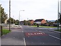
School Lane crosses Kiln Lane in Skelmersdale
Image: © Raymond Knapman
Taken: 22 Sep 2010
0.20 miles
3
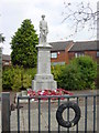
War Memorial, Old Skelmersdale
Situated near the Victoria Hotel at the bottom of Sandy Lane, Old Skelmersdale
Image: © Sue Adair
Taken: 15 Oct 2005
0.22 miles
4

The Market Gate at Sandy Lane Centre
Image: © Raymond Knapman
Taken: 22 Sep 2010
0.23 miles
5
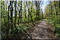
Woodland path by Neverstitch Road
Part of the design to make you feel you are in the country.
Image: © Bill Boaden
Taken: 4 May 2013
0.24 miles