IMAGES TAKEN NEAR TO
Brandreth Drive, WIGAN, WN8 7HB
Introduction
This page details the photographs taken nearby to Brandreth Drive, WN8 7HB by members of the Geograph project.
The Geograph project started in 2005 with the aim of publishing, organising and preserving representative images for every square kilometre of Great Britain, Ireland and the Isle of Man.

There are currently over 7.5m images from over14,400 individuals and you can help contribute to the project by visiting https://www.geograph.org.uk
Image Map
Images are licensed for reuse under creativecommons.org/licenses/by-sa/2.0
Notes
- Clicking on the map will re-center to the selected point.
- The higher the marker number, the further away the image location is from the centre of the postcode.
Image Listing (125 Images Found)
Images are licensed for reuse under creativecommons.org/licenses/by-sa/2.0
Image
Details
Distance
1
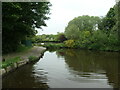
Disused canal arm, Parbold
In 1845, the site of Parbold graving dock. Now the former junction is a winding hole.
Image: © Christine Johnstone
Taken: 28 May 2021
0.09 miles
2
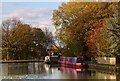
Colourful canal boats
A pair of colourful houseboats moored on the Leeds and Liverpool Canal at Parbold.
Image: © Chris Denny
Taken: 21 Nov 2013
0.11 miles
3
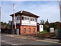
Parbold signal box and level crossing
Image: © Raymond Knapman
Taken: 22 Sep 2010
0.11 miles
5
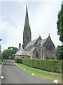
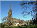
All Saints Parbold
This Church's Sunday Best Name is "Our Lady and All Saints". It is served by the Benedictines of Ampleforth Abbey and was consecrated on 28th May 1884. This beautiful large building is too close to the road to photograph in one go, so the image you see is two photographs stitched together electronically!
Image: © David Hignett
Taken: 13 Jul 2005
0.12 miles
6
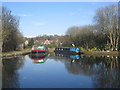
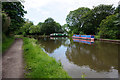
Barges moored alongside the Leeds and Liverpool Canal
This image shows two barges moored alongside the Leeds and Liverpool Canal near Parbold Village. The photograph was taken from the canal bank between the bridges at Mill Lane and Alder Lane (A5209).
Image: © Scott Henderson
Taken: 4 Feb 2007
0.12 miles
7
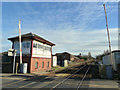
Parbold Station Level Crossing and Signal Box
Image: © Gary Rogers
Taken: 5 Feb 2015
0.13 miles
8
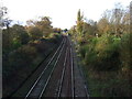
Railway heading north west
Towards Southport.
Image: © JThomas
Taken: 25 Oct 2014
0.13 miles
10
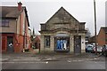
Former bank in Parbold
The building still shows the arms of District Bank, one of the banks in the merger which produced National Westminster Bank. It is now a dress shop. The spire of the Catholic church is seen to the left.
Image: © Bill Boaden
Taken: 28 Feb 2024
0.13 miles