IMAGES TAKEN NEAR TO
Marland, SKELMERSDALE, WN8 6ST
Introduction
This page details the photographs taken nearby to Marland, WN8 6ST by members of the Geograph project.
The Geograph project started in 2005 with the aim of publishing, organising and preserving representative images for every square kilometre of Great Britain, Ireland and the Isle of Man.

There are currently over 7.5m images from over14,400 individuals and you can help contribute to the project by visiting https://www.geograph.org.uk
Image Map
Images are licensed for reuse under creativecommons.org/licenses/by-sa/2.0
Notes
- Clicking on the map will re-center to the selected point.
- The higher the marker number, the further away the image location is from the centre of the postcode.
Image Listing (16 Images Found)
Images are licensed for reuse under creativecommons.org/licenses/by-sa/2.0
Image
Details
Distance
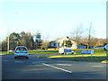
1
Subway under Ashmead Road, Ashurst, Skelmersdale
Image: © Gary Rogers
Taken: 5 Mar 2016
0.12 miles
2

Paths North of Mountwod, Ashurst, Skelmersdale
Image: © Gary Rogers
Taken: 5 Mar 2016
0.15 miles
3
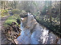
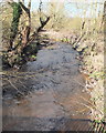
River Tawd between Summer Street and Houghtons Road, Skelmersdale
Image: © Gary Rogers
Taken: 5 Mar 2016
0.16 miles
4
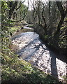
River Tawd near Lathom High School, Skelmersdale
Image: © Gary Rogers
Taken: 5 Mar 2016
0.16 miles
5
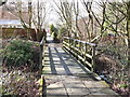
Footbridge over stream between Merewood and Melbreck, Ashurst
Image: © Gary Rogers
Taken: 5 Mar 2016
0.18 miles
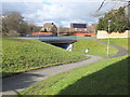
6
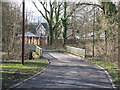
Summer Street bridge over the River Tawd, Skelmersdale
Image: © Gary Rogers
Taken: 5 Mar 2016
0.20 miles
7
River Tawd at Summer Street Bridge, Skelmersdale
Image: © Gary Rogers
Taken: 5 Mar 2016
0.20 miles
9
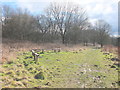
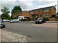
Path near Cobb's Wood, Melbreck, Skelmersdale
Image: © Gary Rogers
Taken: 5 Mar 2016
0.21 miles