IMAGES TAKEN NEAR TO
Ennerdale, SKELMERSDALE, WN8 6AH
Introduction
This page details the photographs taken nearby to Ennerdale, WN8 6AH by members of the Geograph project.
The Geograph project started in 2005 with the aim of publishing, organising and preserving representative images for every square kilometre of Great Britain, Ireland and the Isle of Man.

There are currently over 7.5m images from over14,400 individuals and you can help contribute to the project by visiting https://www.geograph.org.uk
Image Map
Images are licensed for reuse under creativecommons.org/licenses/by-sa/2.0
Notes
- Clicking on the map will re-center to the selected point.
- The higher the marker number, the further away the image location is from the centre of the postcode.
Image Listing (16 Images Found)
Images are licensed for reuse under creativecommons.org/licenses/by-sa/2.0
Image
Details
Distance
1
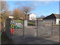
Tanhouse Skatepark
Another contender for the title of the UK's worst skatepark award
Image: © Gary Rogers
Taken: 22 Feb 2016
0.07 miles
3
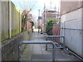
Path between Elmridge and Enstone, Tanhouse
Image: © Gary Rogers
Taken: 22 Feb 2016
0.10 miles
4
Path between Elmridge and Enstone, Tanhouse
Image: © Gary Rogers
Taken: 22 Feb 2016
0.13 miles
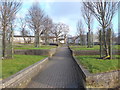
5
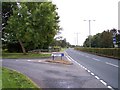
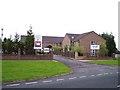
Tanhouse Road at Eavesdale
One of the many grass verged roads of Skelmersdale
Image: © Raymond Knapman
Taken: 17 Aug 2010
0.14 miles
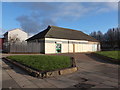
6
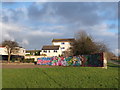
Recreation area, Tanhouse, Skelmersdale
Image: © Gary Rogers
Taken: 22 Feb 2016
0.15 miles
7
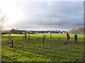
Outdoor gym, Tanhouse, Skelmersdale
Being used by a Bulgarian guy from Pleven who works for a local food manufacturer
Image: © Gary Rogers
Taken: 22 Feb 2016
0.16 miles
8
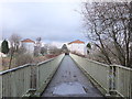
Footbridge over Grimshaw Road leading to Tanhouse
Image: © Gary Rogers
Taken: 22 Feb 2016
0.19 miles
10
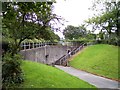
Pedestrian subway under Tanhouse Road
One of many in Skelmersdale to enable pedestrian crossing of major roads
Image: © Raymond Knapman
Taken: 17 Aug 2010
0.19 miles