IMAGES TAKEN NEAR TO
St. Gabriels Close, SKELMERSDALE, WN8 0QS
Introduction
This page details the photographs taken nearby to St. Gabriels Close, WN8 0QS by members of the Geograph project.
The Geograph project started in 2005 with the aim of publishing, organising and preserving representative images for every square kilometre of Great Britain, Ireland and the Isle of Man.

There are currently over 7.5m images from over14,400 individuals and you can help contribute to the project by visiting https://www.geograph.org.uk
Image Map
Images are licensed for reuse under creativecommons.org/licenses/by-sa/2.0
Notes
- Clicking on the map will re-center to the selected point.
- The higher the marker number, the further away the image location is from the centre of the postcode.
Image Listing (44 Images Found)
Images are licensed for reuse under creativecommons.org/licenses/by-sa/2.0
Image
Details
Distance
1
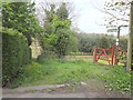
Footpath from School Lane, Walthew Green to Bank Top
Image: © Gary Rogers
Taken: 27 Apr 2017
0.04 miles
2

Road junction at Walthew Green
Lafford Lane to the right, straight on for Walthew Green
Image: © Raymond Knapman
Taken: 18 Apr 2009
0.05 miles
3

Junction of Lafford Lane and School Lane, Walthew Green
Image: © Gary Rogers
Taken: 27 Apr 2017
0.05 miles


6

Fields East of Lafford Lane, Walthew Green
Image: © Gary Rogers
Taken: 27 Apr 2017
0.10 miles

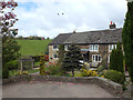
9

Autumn sunlight at Walthew Green
The sign on left is for Walthew House
Image: © Raymond Knapman
Taken: 13 Oct 2010
0.14 miles
10
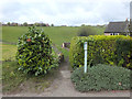
Footpath from Whitley Road to Cliff's Farm, Roby Mill
Image: © Gary Rogers
Taken: 27 Apr 2017
0.14 miles