IMAGES TAKEN NEAR TO
Higher View, SKELMERSDALE, WN8 0NG
Introduction
This page details the photographs taken nearby to Higher View, WN8 0NG by members of the Geograph project.
The Geograph project started in 2005 with the aim of publishing, organising and preserving representative images for every square kilometre of Great Britain, Ireland and the Isle of Man.

There are currently over 7.5m images from over14,400 individuals and you can help contribute to the project by visiting https://www.geograph.org.uk
Image Map
Images are licensed for reuse under creativecommons.org/licenses/by-sa/2.0
Notes
- Clicking on the map will re-center to the selected point.
- The higher the marker number, the further away the image location is from the centre of the postcode.
Image Listing (16 Images Found)
Images are licensed for reuse under creativecommons.org/licenses/by-sa/2.0
Image
Details
Distance

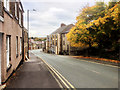
4
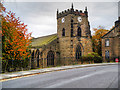
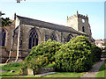
Up Holland, The Parish Church of St Thomas the Martyr
Formerly the chancel of the Benedictine Priory of Up Holland founded in 1317-18 and with a late-fifteenth century west tower. St Thomas’ Church is a Grade I listed building (English Heritage Building ID: 388993 http://www.britishlistedbuildings.co.uk/en-388993-church-of-st-thomas-the-martyr-up-hollan#.Vi5gVHknyHs British Listed Buildings).
Image: © David Dixon
Taken: 23 Oct 2015
0.14 miles
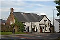
5
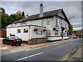
Up Holland, The White Lion
Public house opposite Image
Image: © David Dixon
Taken: 23 Oct 2015
0.15 miles
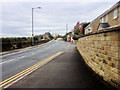
6
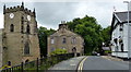
Church of St Thomas the Martyr, Upholland
Along Church Street, with the White Lion public house on the right.
Image: © Mat Fascione
Taken: 27 Jun 2016
0.16 miles
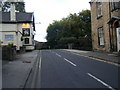
7
The Parish Church of St Thomas the Martyr, Up Holland
Formerly the chancel of the Benedictine Priory of Up Holland founded in 1317-18 and with a late-fifteenth century west tower. St Thomas’ Church is a Grade I listed building (English Heritage Building ID: 388993 http://www.britishlistedbuildings.co.uk/en-388993-church-of-st-thomas-the-martyr-up-hollan#.Vi5gVHknyHs British Listed Buildings).
Image: © David Dixon
Taken: 23 Oct 2015
0.17 miles
8
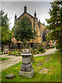
The Church of St Thomas the Martyr, Upholland
Information here http://www.stthomasthemartyr.org.uk/index.htm
Image: © Karl and Ali
Taken: 5 Sep 2010
0.17 miles