IMAGES TAKEN NEAR TO
Tower Hill Road, SKELMERSDALE, WN8 0DS
Introduction
This page details the photographs taken nearby to Tower Hill Road, WN8 0DS by members of the Geograph project.
The Geograph project started in 2005 with the aim of publishing, organising and preserving representative images for every square kilometre of Great Britain, Ireland and the Isle of Man.

There are currently over 7.5m images from over14,400 individuals and you can help contribute to the project by visiting https://www.geograph.org.uk
Image Map
Images are licensed for reuse under creativecommons.org/licenses/by-sa/2.0
Notes
- Clicking on the map will re-center to the selected point.
- The higher the marker number, the further away the image location is from the centre of the postcode.
Image Listing (8 Images Found)
Images are licensed for reuse under creativecommons.org/licenses/by-sa/2.0
Image
Details
Distance
1

M58
Looking east from the bridge over the motorway on the edge of the adjacent grid square.
Image: © Gary Rogers
Taken: 16 Jun 2005
0.08 miles

7
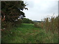
Footpath off Tower Hill Road
Towards Up Holland.
Image: © JThomas
Taken: 13 Sep 2014
0.23 miles
8

Farm Track at Well Cross Farm, Up Holland
Leading to the foot bridge over the M58
Image: © Gary Rogers
Taken: 9 Oct 2014
0.25 miles