IMAGES TAKEN NEAR TO
Sovereign Fold Road, LEIGH, WN7 5HX
Introduction
This page details the photographs taken nearby to Sovereign Fold Road, WN7 5HX by members of the Geograph project.
The Geograph project started in 2005 with the aim of publishing, organising and preserving representative images for every square kilometre of Great Britain, Ireland and the Isle of Man.

There are currently over 7.5m images from over14,400 individuals and you can help contribute to the project by visiting https://www.geograph.org.uk
Image Map (Loading...)


Getting Data...Please wait
Leaflet Map data © OpenStreetMap
Images are licensed for reuse under creativecommons.org/licenses/by-sa/2.0
Notes
- Clicking on the map will re-center to the selected point.
- The higher the marker number, the further away the image location is from the centre of the postcode.
Image Listing (13 Images Found)
Images are licensed for reuse under creativecommons.org/licenses/by-sa/2.0
Image
Details
Distance
1

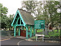
The Church Inn, Pickley Green, outside St. Paul's Church
Image: © David Long
Taken: 17 Nov 2005
0.11 miles
2
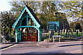
St Paul's Church and Lychgate, Pickley Green
The church of St Paul, Pickley Green (Westleigh) was consecrated in 1847. It was formerly a chapel of ease to the parish church of Leigh. It is a building of stone, consisting of chancel, nave, south aisle, south porch, and a tower on the south side containing one bell.
From: 'Townships: Westleigh', A History of the County of Lancaster: Volume 3 (1907), pp. 421-426. http://www.british-history.ac.uk/report.aspx?compid=41360 Date accessed: 13 May 2012.
Image: © David Dixon
Taken: 11 May 2012
0.12 miles
3
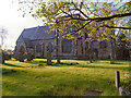
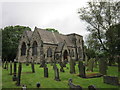
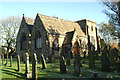
St Paul's Church, Pickley Green
The church of St Paul, Pickley Green (Westleigh) was consecrated in 1847. It was formerly a chapel of ease to the parish church of Leigh. It is a building of stone, consisting of chancel, nave, south aisle, south porch, and a tower on the south side containing one bell.
From: 'Townships: Westleigh', A History of the County of Lancaster: Volume 3 (1907), pp. 421-426. http://www.british-history.ac.uk/report.aspx?compid=41360 Date accessed: 13 May 2012.
Image: © David Dixon
Taken: 11 May 2012
0.13 miles
4
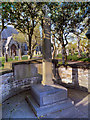
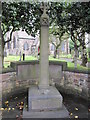
War Memorial and St Paul's Church, Pickley Green
The war memorial is sited next to the lychgate at the entrance to St Paul's Church which can be seen behind the memorial.
Image: © David Dixon
Taken: 11 May 2012
0.13 miles
7
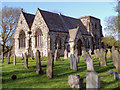
The church of St Paul, Pickley Green (Westleigh)
The church of St Paul, Pickley Green (Westleigh) was consecrated in 1847. It was formerly a chapel of ease to the parish church of Leigh. It is a building of stone, consisting of chancel, nave, south aisle, south porch, and a tower on the south side containing one bell.
From: 'Townships: Westleigh', A History of the County of Lancaster: Volume 3 (1907), pp. 421-426. http://www.british-history.ac.uk/report.aspx?compid=41360 Date accessed: 13 May 2012.
Image: © David Dixon
Taken: 11 May 2012
0.13 miles
10
St. Paul's Church, Westleigh, on Westleigh Lane
Image: © David Long
Taken: 17 Nov 2005
0.17 miles