IMAGES TAKEN NEAR TO
Wilds Passage, King Street, LEIGH, WN7 4LL
Introduction
This page details the photographs taken nearby to Wilds Passage, King Street, WN7 4LL by members of the Geograph project.
The Geograph project started in 2005 with the aim of publishing, organising and preserving representative images for every square kilometre of Great Britain, Ireland and the Isle of Man.

There are currently over 7.5m images from over14,400 individuals and you can help contribute to the project by visiting https://www.geograph.org.uk
Image Map (Loading...)


Getting Data...Please wait
Leaflet Map data © OpenStreetMap
Images are licensed for reuse under creativecommons.org/licenses/by-sa/2.0
Notes
- Clicking on the map will re-center to the selected point.
- The higher the marker number, the further away the image location is from the centre of the postcode.
Image Listing (89 Images Found)
Images are licensed for reuse under creativecommons.org/licenses/by-sa/2.0
Image
Details
Distance
1
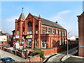
King Street Wesleyan Methodist Church Leigh
The former Wesleyan Methodist church, at King Street in Leigh, was founded in 1870. It closed before 1980 and is now occupied by several small businesses.
http://genuki.org.uk/cgi-bin/churches?CCC=LAN,GR=2342,FT=Leigh%20King%20St%20Wesleyan%20Methodist - Genuki
http://www.lan-opc.org.uk/Leigh/leighwes.html - Lancashire On line
Image: © David Dixon
Taken: 24 Mar 2011
0.02 miles
2
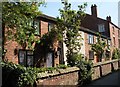
Wild's Passage, Leigh
This row of cottages is hidden away from the main thoroughfare.
Image: © SMJ
Taken: 13 May 2008
0.03 miles
3
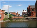
Looking towards Leigh centre
This view from the canal bank at Leigh Bridge looks down King Street towards the town centre. The red brick building on the right is King St Methodist School now converted for other uses.
Image: © SMJ
Taken: 13 May 2008
0.03 miles
4
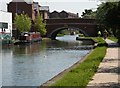
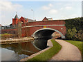
Leigh Bridge
This bridge carries the A572 road over the Leeds and Liverpool Canal.
Image: © SMJ
Taken: 13 May 2008
0.03 miles
5
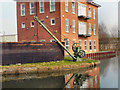
Bridgewater Canal, Crane and Board, Leigh
This crane, situated near Leigh Bridge, at the western end of the Bridgewater Canal, is one of several which are located at intervals along the canal's length to allow boards to be dropped into slots in the banks. These allow sections of the canal to be isolated in the event of a leak. If you look carefully, you can see the slot in the bank just below the crane.
Image: © David Dixon
Taken: 24 Mar 2011
0.04 miles
6
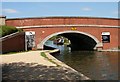
Leigh Bridge
This bridge carries the A572 road over the Leeds and Liverpool Canal.
Image: © SMJ
Taken: 14 May 2008
0.04 miles
7
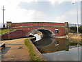
Leigh Bridge
Leigh Bridge, carrying St Helens Road (A572) over the end of the Bridgewater Canal/start of the Leeds and Liverpool Canal. The Bridgewater Canal was extended from Worsley to the middle of Leigh in 1795, and by 1820 the Leigh branch canal was cut from the Leeds-Liverpool Canal at Poolstock, Wigan to meet the Bridgewater at Leigh Bridge.
Image: © David Dixon
Taken: 24 Mar 2011
0.05 miles
8
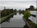
Leigh, canal
Leeds and Liverpool Canal, as seen from Leigh Bridge. For other local canal scenes, see http://www.penninewaterways.co.uk/bridgewater/bri70.htm
Image: © Mike Faherty
Taken: 18 Oct 2009
0.05 miles
9
Leeds and Liverpool Canal, Leigh Bridge
Leigh Bridge, carrying St Helens Road (A572) over the end of the Leeds and Liverpool Canal/start of the Bridgewater Canal. The Bridgewater Canal was extended from Worsley to the middle of Leigh in 1795, and by 1820 the Leigh branch canal was cut from the Leeds-Liverpool Canal at Poolstock, Wigan to meet the Bridgewater at Leigh Bridge.
Image: © David Dixon
Taken: 24 Mar 2011
0.05 miles
10
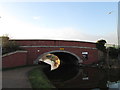
Leigh Bridge
On this side of the bridge is the Bridgewater Canal. Beyond is the Leeds and Liverpool Canal towards Wigan.
Image: © John Slater
Taken: 20 Jan 2014
0.06 miles