IMAGES TAKEN NEAR TO
Clarke Street, LEIGH, WN7 4HU
Introduction
This page details the photographs taken nearby to Clarke Street, WN7 4HU by members of the Geograph project.
The Geograph project started in 2005 with the aim of publishing, organising and preserving representative images for every square kilometre of Great Britain, Ireland and the Isle of Man.

There are currently over 7.5m images from over14,400 individuals and you can help contribute to the project by visiting https://www.geograph.org.uk
Image Map
Images are licensed for reuse under creativecommons.org/licenses/by-sa/2.0
Notes
- Clicking on the map will re-center to the selected point.
- The higher the marker number, the further away the image location is from the centre of the postcode.
Image Listing (26 Images Found)
Images are licensed for reuse under creativecommons.org/licenses/by-sa/2.0
Image
Details
Distance
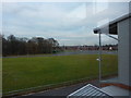
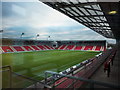
2
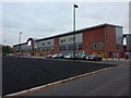
Standing room only
Northern stand at Leigh Centurion Rugby Ground, Leigh Sports Village
Image: © Alexander P Kapp
Taken: 15 Dec 2010
0.15 miles
4
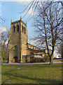
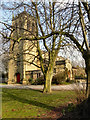
Pennington Christ Church
Pennington Christ Church, at the corner of Schofield Street and St Helens Road, was built in the mid nineteenth century during a period when the site to the south of the canal was a rapidly growing area. Constructed of Yorkshire stone, it was consecrated in 1854. It is a Grade II listed building.
This is the view of the tower and western side of the church, from Schofield Street.
(http://www.imagesofengland.org.uk/details/default.aspx?id=213507 – Images of England)
Image: © David Dixon
Taken: 24 Mar 2011
0.17 miles
5
Christ Church, Pennington
Pennington Christ Church, at the corner of Schofield Street and St Helens Road, was built in the mid nineteenth century during a period when the site to the south of the canal was a rapidly growing area. Constructed of Yorkshire stone, it was consecrated in 1854. It is a Grade II listed building.
This is the view from Schofield Street.
(http://www.imagesofengland.org.uk/details/default.aspx?id=213507 – Images of England)
Image: © David Dixon
Taken: 24 Mar 2011
0.17 miles
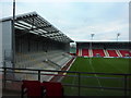
6
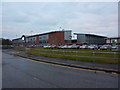
Front view of the rugby ground, Leigh Sports Village
Image: © Alexander P Kapp
Taken: 15 Dec 2010
0.17 miles
8
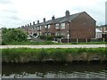
Lilford Street, Leigh
On the south bank of the Leeds & Liverpool canal.
Image: © Christine Johnstone
Taken: 23 May 2021
0.17 miles
9
Leigh Sports Village, home of Leigh Centurions
http://www.leighsportsvillage.co.uk/
Image: © Alexander P Kapp
Taken: 15 Dec 2010
0.18 miles
10

Christ Church, Pennington
Pennington Christ Church, at the corner of Schofield Street and St Helens Road, was built in the mid nineteenth century during a period when the site to the south of the canal was a rapidly growing area. Constructed of Yorkshire stone, it was consecrated in 1854. It is a Grade II listed building. (http://www.imagesofengland.org.uk/details/default.aspx?id=213507 – Images of England)
Image: © David Dixon
Taken: 24 Mar 2011
0.18 miles