IMAGES TAKEN NEAR TO
Coniston Street, LEIGH, WN7 4FR
Introduction
This page details the photographs taken nearby to Coniston Street, WN7 4FR by members of the Geograph project.
The Geograph project started in 2005 with the aim of publishing, organising and preserving representative images for every square kilometre of Great Britain, Ireland and the Isle of Man.

There are currently over 7.5m images from over14,400 individuals and you can help contribute to the project by visiting https://www.geograph.org.uk
Image Map
Images are licensed for reuse under creativecommons.org/licenses/by-sa/2.0
Notes
- Clicking on the map will re-center to the selected point.
- The higher the marker number, the further away the image location is from the centre of the postcode.
Image Listing (52 Images Found)
Images are licensed for reuse under creativecommons.org/licenses/by-sa/2.0
Image
Details
Distance
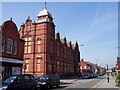
4
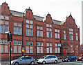
Leigh - former municipal college and library
On Railway Road.
Image: © Dave Bevis
Taken: 9 Sep 2014
0.09 miles
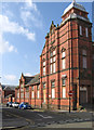
5
The old Free Library in Railway Street
Derelict library building
Image: © Raymond Knapman
Taken: 1 Sep 2010
0.09 miles
6
Leigh - former college on Ullswater Street
Image: © Dave Bevis
Taken: 9 Sep 2014
0.09 miles
7
The Atherleigh Harvester, Leigh
Parsonage Way LEIGH WN7 5SJ near to The Leeds and Liverpool Canal Leigh Branch
Image: © canalandriversidepubs co uk
Taken: 9 Apr 2010
0.10 miles
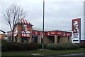
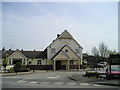
9
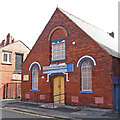
Leigh - Pentecostal Church
On Ullswater Street.
Image: © Dave Bevis
Taken: 9 Sep 2014
0.11 miles
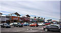
10
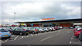
Sainsbury's Parsonage Retail Park, Leigh
Image: © Richard Cooke
Taken: 14 Feb 2015
0.12 miles