IMAGES TAKEN NEAR TO
St. Helens Road, LEIGH, WN7 3GA
Introduction
This page details the photographs taken nearby to St. Helens Road, WN7 3GA by members of the Geograph project.
The Geograph project started in 2005 with the aim of publishing, organising and preserving representative images for every square kilometre of Great Britain, Ireland and the Isle of Man.

There are currently over 7.5m images from over14,400 individuals and you can help contribute to the project by visiting https://www.geograph.org.uk
Image Map (Loading...)


Getting Data...Please wait
Leaflet Map data © OpenStreetMap
Images are licensed for reuse under creativecommons.org/licenses/by-sa/2.0
Notes
- Clicking on the map will re-center to the selected point.
- The higher the marker number, the further away the image location is from the centre of the postcode.
Image Listing (6 Images Found)
Images are licensed for reuse under creativecommons.org/licenses/by-sa/2.0
Image
Details
Distance
1
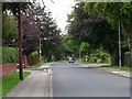
Beech Walk
Looking in a southerly direction down Beech Walk, Pennington, Leigh. Close to Leigh Cricket, Tennis and Bowls Club. SJ65449882
Image: © Keith Williamson
Taken: 19 Sep 2005
0.09 miles
2
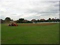
Ground Maintenance
Working on the pitch at Leigh Cricket, Tennis and Bowling Club. SJ65449882
Image: © Keith Williamson
Taken: 19 Sep 2005
0.09 miles
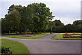
4
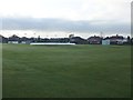
Leigh Cricket Club - Ground
Looking across Leigh CC's Beech Walk ground. The club run four teams in the Liverpool & District Cricket Competition.
Image: © BatAndBall
Taken: 26 Apr 2013
0.15 miles
5
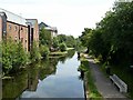
Canal at Leigh
The Leigh branch of the Leeds and Liverpool from King Street Bridge.
Image: © philandju
Taken: 25 Jul 2018
0.18 miles
6
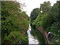
Pennington Brook
Looking downstream from Pennington Mill Bridge, Pennington, Leigh. SJ65419921
Image: © Keith Williamson
Taken: 19 Sep 2005
0.18 miles