IMAGES TAKEN NEAR TO
West Avenue, LEIGH, WN7 3BQ
Introduction
This page details the photographs taken nearby to West Avenue, WN7 3BQ by members of the Geograph project.
The Geograph project started in 2005 with the aim of publishing, organising and preserving representative images for every square kilometre of Great Britain, Ireland and the Isle of Man.

There are currently over 7.5m images from over14,400 individuals and you can help contribute to the project by visiting https://www.geograph.org.uk
Image Map
Images are licensed for reuse under creativecommons.org/licenses/by-sa/2.0
Notes
- Clicking on the map will re-center to the selected point.
- The higher the marker number, the further away the image location is from the centre of the postcode.
Image Listing (53 Images Found)
Images are licensed for reuse under creativecommons.org/licenses/by-sa/2.0
Image
Details
Distance
1
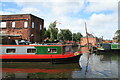
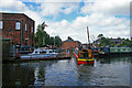
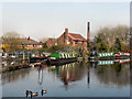
Bridgewater Canal, Leigh
Looking into some moorings in a small basin in the Bedford area of Leigh.
Image: © Chris Allen
Taken: 25 Jun 2016
0.07 miles
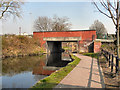
2
Butt's Bridge [no 64], from the west
Carrying the Warrington Road over the Bridgewater canal.
Image: © Christine Johnstone
Taken: 29 May 2021
0.07 miles
3
Bridgewater Canal, Butts Bridge
The bridge carrying Warrington Road (A574) over The Bridgewater Canal, at Leigh.
Image: © David Dixon
Taken: 24 Mar 2011
0.07 miles
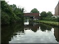
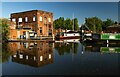
4
Butts Basin, Leigh
In 1845 this basin served a flour mill [where the brick building is] and lime kilns [beyond the shrubs].
Image: © Christine Johnstone
Taken: 23 May 2021
0.08 miles
5
Canal mooring, Leigh
On the Bridgewater Canal.
Image: © Chris Allen
Taken: 25 Jun 2016
0.08 miles
6
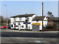
The Wheatsheaf
Situated at the junction of Warrington Road, Manchester Road and Chapel Street, next to the Bridgewater Canal at Butts Bridge. The Wheatsheaf was almost certainly originally built during the nineteenth century, to serve travellers using these busy trade routes.
Image: © David Dixon
Taken: 24 Mar 2011
0.08 miles
7
Bridgewater Canal, Leigh
With some moorings and a small basin on the far side.
Image: © Chris Allen
Taken: 25 Jun 2016
0.08 miles
8
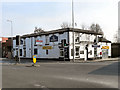
The Wheatsheaf
At the junction of Warrington Road, Manchester Road and Chapel Street, next to the Bridgewater Canal at Butts Bridge. Almost certainly, it was originally built to take advantage of travellers using the canal or the Manchester-Warrington road route during the nineteenth century.
Image: © David Dixon
Taken: 24 Mar 2011
0.08 miles
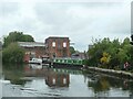
9
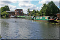
Bridgewater Canal, Butts Basin
Butts Basin, on the Bridgewater Canal at Leigh.
Image: © David Dixon
Taken: 24 Mar 2011
0.08 miles
10
Bridgewater Canal
The Bridgewater Canal in Leigh.
Image: © Peter McDermott
Taken: 5 Jun 2021
0.08 miles