IMAGES TAKEN NEAR TO
College Street, LEIGH, WN7 2RF
Introduction
This page details the photographs taken nearby to College Street, WN7 2RF by members of the Geograph project.
The Geograph project started in 2005 with the aim of publishing, organising and preserving representative images for every square kilometre of Great Britain, Ireland and the Isle of Man.

There are currently over 7.5m images from over14,400 individuals and you can help contribute to the project by visiting https://www.geograph.org.uk
Image Map
Images are licensed for reuse under creativecommons.org/licenses/by-sa/2.0
Notes
- Clicking on the map will re-center to the selected point.
- The higher the marker number, the further away the image location is from the centre of the postcode.
Image Listing (52 Images Found)
Images are licensed for reuse under creativecommons.org/licenses/by-sa/2.0
Image
Details
Distance
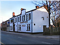
1
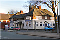
Eagle and Hawk, Leigh
The Eagle and Hawk public house on Chapel Street, Leigh.
Image: © David Dixon
Taken: 18 Mar 2011
0.07 miles
2
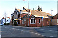
St Joseph's Hall, Leigh
St Joseph's Hall is at the corner of Mather Lane and Chapel Street in Leigh, just in front of Image The hall was built in 1925.
Image: © David Dixon
Taken: 18 Mar 2011
0.08 miles
3
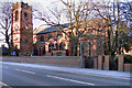
St Joseph's Church, Leigh
Looking across Chapel Street towards the entrance to the grounds of Image The church is a Grade II listed building.
Image: © David Dixon
Taken: 18 Mar 2011
0.10 miles
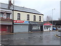
4
Standard Mower
The Standard Mower public house, 88 Chapel Street, Leigh.
Image: © David Dixon
Taken: 18 Mar 2011
0.11 miles
6
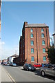
Warehouse, Brown Street North
This building was originally the Derby Brewery.
Image: © SMJ
Taken: 11 Sep 2009
0.11 miles
7
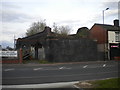
Railway remnant, Queen Street, Leigh
Presumably because its arches are occupied, this short section of railway viaduct has outlived the rest of the structure. Built to carry the former London & North Western Railway line between Leigh and Tyldesley, it now stands forlornly on the eastern edge of the town centre. Just north of here, a guided busway along the trackbed of the railway begins.
Image: © Richard Vince
Taken: 23 Apr 2016
0.11 miles
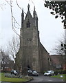
8
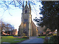
The Parish Church of St Thomas with All Saints, Leigh
St Thomas' Church, on Chapel Street in Leigh, was consecrated in 1840. It was rebuilt between 1902 and 1910. (http://www.stthomasleigh.co.uk/index.php?page=parish-history - Parish history)
Image: © David Dixon
Taken: 18 Mar 2011
0.12 miles
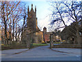
9
Church of St. Joseph, Leigh
St Joseph's Roman Catholic Church is a Grade II listed building on Chapel Street in Leigh. It was built in 1855. This view is from the Chapel Street entrance.
http://www.britishlistedbuildings.co.uk/en-213492-church-of-st-joseph-leigh - British Listed Buildings
Image: © David Dixon
Taken: 18 Mar 2011
0.12 miles