IMAGES TAKEN NEAR TO
Hadfield Grove, LEIGH, WN7 2ET
Introduction
This page details the photographs taken nearby to Hadfield Grove, WN7 2ET by members of the Geograph project.
The Geograph project started in 2005 with the aim of publishing, organising and preserving representative images for every square kilometre of Great Britain, Ireland and the Isle of Man.

There are currently over 7.5m images from over14,400 individuals and you can help contribute to the project by visiting https://www.geograph.org.uk
Image Map (Loading...)


Getting Data...Please wait
Leaflet Map data © OpenStreetMap
Images are licensed for reuse under creativecommons.org/licenses/by-sa/2.0
Notes
- Clicking on the map will re-center to the selected point.
- The higher the marker number, the further away the image location is from the centre of the postcode.
Image Listing (12 Images Found)
Images are licensed for reuse under creativecommons.org/licenses/by-sa/2.0
Image
Details
Distance

7
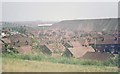
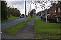
Higher Folds 1974
Although the houses on this estate are mostly the same as in 1974 and there is still only one road into it, the surroundings are much improved, with the ever visible spoil heaps (locally called 'rucks') now landscaped with woods and footpaths.
Image: © Chris Denny
Taken: Unknown
0.15 miles
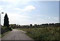
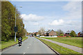
10
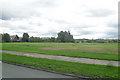
Open Land off Queensway - Higher Folds
Image: © Anthony Parkes
Taken: 31 Jul 2010
0.22 miles