IMAGES TAKEN NEAR TO
Clyde Street, LEIGH, WN7 2AU
Introduction
This page details the photographs taken nearby to Clyde Street, WN7 2AU by members of the Geograph project.
The Geograph project started in 2005 with the aim of publishing, organising and preserving representative images for every square kilometre of Great Britain, Ireland and the Isle of Man.

There are currently over 7.5m images from over14,400 individuals and you can help contribute to the project by visiting https://www.geograph.org.uk
Image Map
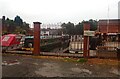
Images are licensed for reuse under creativecommons.org/licenses/by-sa/2.0
Notes
- Clicking on the map will re-center to the selected point.
- The higher the marker number, the further away the image location is from the centre of the postcode.
Image Listing (91 Images Found)
Images are licensed for reuse under creativecommons.org/licenses/by-sa/2.0
Image
Details
Distance
1
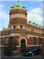
Alder Mill
This ornate office building is all that remains of the large Alder Mill, designed by Stotts of Oldham in their trademark terracotta style. Despite the visible date, the mill was apparently built in 1905.
Image: © Alan Murray-Rust
Taken: 18 Sep 2009
0.01 miles
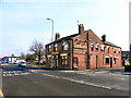
2
The remains of Alder Mill, Leigh
Alder Mill was a large 5 storey spinning mill built in 1907 and powered by a 1800 horsepower Browett, Lindley inverted vertical triple expansion engine. This office cum gatehouse with the gates alongside is all that remains. I saw this mill in 1980 but didn't 'waste' any film on it.
Image: © Chris Allen
Taken: 25 Jun 2016
0.01 miles
3
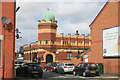
The Wheatsheaf
At the junction of Warrington Road, Manchester Road and Chapel Street, next to the Bridgewater Canal at Butts Bridge. Almost certainly, it was originally built to take advantage of travellers using the canal or the Manchester-Warrington road route during the nineteenth century.
Image: © David Dixon
Taken: 24 Mar 2011
0.04 miles
4
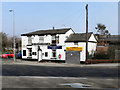
The Wheatsheaf
Situated at the junction of Warrington Road, Manchester Road and Chapel Street, next to the Bridgewater Canal at Butts Bridge. The Wheatsheaf was almost certainly originally built during the nineteenth century, to serve travellers using these busy trade routes.
Image: © David Dixon
Taken: 24 Mar 2011
0.05 miles
5
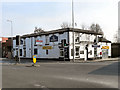
The Foundry
Public house at the corner of Chapel Street and Foundry Street, in Leigh.
Image: © David Dixon
Taken: 24 Mar 2011
0.05 miles
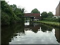
6
Forty years on:Butts Basin
While the basin itself looks pretty much the same as inImage], the huge bulk of Alder Mill has gone, replaced by housing.
Image: © Chris Denny
Taken: 10 Nov 2014
0.06 miles
7
Butt's Bridge [no 64], from the west
Carrying the Warrington Road over the Bridgewater canal.
Image: © Christine Johnstone
Taken: 29 May 2021
0.07 miles
8
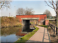
Bridgewater Canal, Butts Bridge
The bridge carrying Warrington Road (A574) over The Bridgewater Canal, at Leigh.
Image: © David Dixon
Taken: 24 Mar 2011
0.07 miles
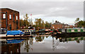
9
Butts Basin
The Marina at Butts Basin looking across from Bangor Fold.
Image: © Steve Houldsworth
Taken: 8 Aug 2024
0.07 miles
10
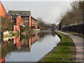
Bridgewater Canal, Leigh
Looking east along the towpath of the Bridgewater Canal, near to the Warrington Road Bridge, at Leigh.
Image: © David Dixon
Taken: 24 Mar 2011
0.07 miles