IMAGES TAKEN NEAR TO
Leigh Road, LEIGH, WN7 1SH
Introduction
This page details the photographs taken nearby to Leigh Road, WN7 1SH by members of the Geograph project.
The Geograph project started in 2005 with the aim of publishing, organising and preserving representative images for every square kilometre of Great Britain, Ireland and the Isle of Man.

There are currently over 7.5m images from over14,400 individuals and you can help contribute to the project by visiting https://www.geograph.org.uk
Image Map (Loading...)


Getting Data...Please wait
Leaflet Map data © OpenStreetMap
Images are licensed for reuse under creativecommons.org/licenses/by-sa/2.0
Notes
- Clicking on the map will re-center to the selected point.
- The higher the marker number, the further away the image location is from the centre of the postcode.
Image Listing (11 Images Found)
Images are licensed for reuse under creativecommons.org/licenses/by-sa/2.0
Image
Details
Distance
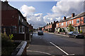
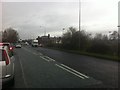
1
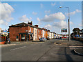
Leigh Road
Entering Leigh on the B5215 from Atherton. "Welcome to Leigh" sign on the right hand side of the road.
Image: © David Dixon
Taken: 11 May 2012
0.02 miles
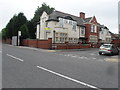
2
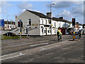
Hilton Park
Public house on Leigh Road.
Image: © David Dixon
Taken: 11 May 2012
0.05 miles
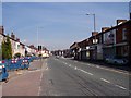
3
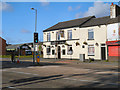
Hilton Park
Public house on Leigh Road.
Image: © David Dixon
Taken: 11 May 2012
0.05 miles
4
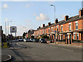
Leigh Road (B5215)
Entering Atherton via the B5215 from Leigh. "Welcome to Atherton" sign on the left hand side of the road.
Image: © David Dixon
Taken: 11 May 2012
0.06 miles
8
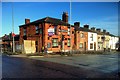
The Victoria Inn
At the junction of Atherleigh Way with Kirkhall Lane.
Image: © David Dixon
Taken: 22 Jan 2016
0.19 miles
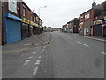
9
Atherleigh Way approaching Kirkhall Lane
Image: © Darrin Antrobus
Taken: 18 Mar 2014
0.22 miles
10
Leigh Road
Notice proclaims 56 casualties in 3 years
Image: © Raymond Knapman
Taken: 1 Sep 2010
0.24 miles