IMAGES TAKEN NEAR TO
Hatherway Court, LEIGH, WN7 1HL
Introduction
This page details the photographs taken nearby to Hatherway Court, WN7 1HL by members of the Geograph project.
The Geograph project started in 2005 with the aim of publishing, organising and preserving representative images for every square kilometre of Great Britain, Ireland and the Isle of Man.

There are currently over 7.5m images from over14,400 individuals and you can help contribute to the project by visiting https://www.geograph.org.uk
Image Map (Loading...)


Getting Data...Please wait
Leaflet Map data © OpenStreetMap
Images are licensed for reuse under creativecommons.org/licenses/by-sa/2.0
Notes
- Clicking on the map will re-center to the selected point.
- The higher the marker number, the further away the image location is from the centre of the postcode.
Image Listing (9 Images Found)
Images are licensed for reuse under creativecommons.org/licenses/by-sa/2.0
Image
Details
Distance

4
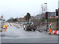
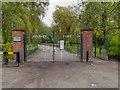
Leigh's new guided busway being constructed
At its junction with Holden Road.
Image: © Gary Rogers
Taken: 9 Mar 2016
0.20 miles
5
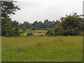
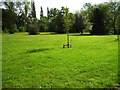
Lilford Park
Open land to the south of Lilford Park
Image: © David Dixon
Taken: 2 Jun 2012
0.23 miles
8
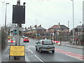
Guided Busway Under Test
Warning sign on Holden Road, Leigh
Image: © Gary Rogers
Taken: 9 Mar 2016
0.24 miles
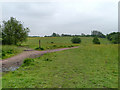
9
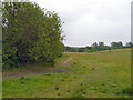
Lilford Park
Open land to the south of Lilford Park, Leigh.
Image: © David Dixon
Taken: 2 Jun 2012
0.24 miles