IMAGES TAKEN NEAR TO
Redfield Croft, LEIGH, WN7 1EN
Introduction
This page details the photographs taken nearby to Redfield Croft, WN7 1EN by members of the Geograph project.
The Geograph project started in 2005 with the aim of publishing, organising and preserving representative images for every square kilometre of Great Britain, Ireland and the Isle of Man.

There are currently over 7.5m images from over14,400 individuals and you can help contribute to the project by visiting https://www.geograph.org.uk
Image Map
Images are licensed for reuse under creativecommons.org/licenses/by-sa/2.0
Notes
- Clicking on the map will re-center to the selected point.
- The higher the marker number, the further away the image location is from the centre of the postcode.
Image Listing (27 Images Found)
Images are licensed for reuse under creativecommons.org/licenses/by-sa/2.0
Image
Details
Distance

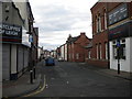
2
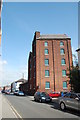
Warehouse, Brown Street North
This building was originally the Derby Brewery.
Image: © SMJ
Taken: 11 Sep 2009
0.16 miles
3
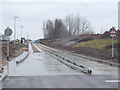
Leigh's new guided busway being constructed
At its junction with Holden Road
Image: © Gary Rogers
Taken: 9 Mar 2016
0.16 miles
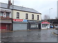
6
Bedford Street, Leigh
Seen from Bradshawgate.
Image: © Richard Vince
Taken: 23 Apr 2016
0.18 miles
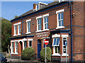
7
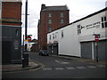
Brown Street North, Leigh
Seen from Bradshawgate.
Image: © Richard Vince
Taken: 23 Apr 2016
0.19 miles
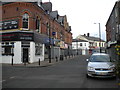
9

Henrietta Street Chippy, Leigh
At the junction of Henrietta Street and Hope Street, Leigh
Image: © Gary Rogers
Taken: 9 Mar 2016
0.20 miles
10
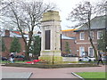
War memorial in Leigh
In a block bounded by Hope Street, Silk Street, Bond Street and Church Street
Image: © Gary Rogers
Taken: 9 Mar 2016
0.20 miles